Kafr Dawar
Kafr Dawar
Kafr Dawar is a large town just before the outskirts of Alexandria on the main Agricultural Road between Cairo and Alexandria. Its main industries include chemicals and textiles. The sites near it are mostly located between the Agricultural Road and the northern coast or shoreline of Lake Idku.
Kom el-Hag (SCA 100155) (Map number 1)
The site is a small, rocky outcrop on the edge of the desert limestone rock formation. The kom is now surrounded by a small ezbet called Ezbet el-Bank and covers an area of approximately 120 m from north to south and 200 m from east to west. It is approximately 4.5 m high above the level of the fields and is now used as a manure store and animals are kept in small sheds on the hill by the nearby village. The fields to the south of the main mound are covered in sherds and must be considered as part of the actual antiquities area, perhaps a settlement or building against the rocky outcrop. It would be interesting to define the exact nature of the site here because of its location and apparent use of the local topography as at Kom Ishu.
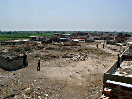
View from the top of Kom el-Hag, showing the height of the hill above the surrounding fields.Kom Ishu (Map number 2)
This site does not seem to have an SCA number and is not marked on the map, unless it has been confused with Kom el-Hag.
The site is situated upon a limestone outcrop at the edge of the northern limestone formation. The dimensions of the rocky outcrop are 150 m from east to west and 200 m from north to south. The rock has a maximum height of approximately 4m and has some steep, almost sheer sides. This would have been a good strategic point with good views across the fields on all sides. It is surrounded on most sides by the village, to the north by a new sports centre and on the north-west by fields. It is covered now with a modern cemetery and some ancient pottery can be found on the ground surface. If there were any ancient structures up here, they must have long since vanished. Some mud brick temporary animal huts were being built on the lower southern slopes. Both Kom el-Hag and Kom Ishu are situated on the southern limits of the old Lake Mareotis and could have had strategic value in guarding the lake shores, or in watching over the desert areas to the west and the river to the south. They are within signalling distance.
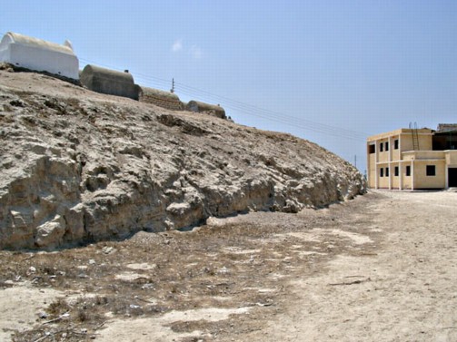
The sheer sides of Kom Ishu with a modern cemetery on its summit.Kom el-Farag (Map number 4)
This site is under a modern town. From the top of a new school building which stands on a high point in the landscape, the view along the main street of this town seems to be a line of sight down the side of the low, sloping mound. From here two other sites were clearly visible to the north-west — Kom Makboura and Kom el-Jil — and to the north Kom el-Mahar could be seen in the distance.
View from Kom el-Farag with Kom el-Jil in the middle distance.Kom el-Mahar (SCA 100167) (Map number 5)
The site covers an area of 440 m from north to south and 200 m from east to west. The main part of the site consists of a 10-12 m-high mound to the north of the area covered in pottery. The soil is very sandy and contains many sea shells. In fact, the name of the site means ‘shell’ and shelly deposits are apparent all over the mound and in the sections as well. To the south-west, the lower slopes of the mound have a modern cemetery built on them and the south-east area of the site has been dug out and flattened.
The north-west side of the mound has sheer sides where they have been dug away and it is likely that the original site extended in all directions away from the mound. It is now surrounded by deep irrigation ditches and fields which are encroaching on the outer parts of the site. A section cut out of the north-western side shows ashlar limestone blocks, a wall made of sandy mud bricks and shell-filled, mud bricks. There are also some fragments of red granite on the mound and a noticeable amount of glass is mixed in with the pottery which includes fine wares such as African Red Slip pottery. Pottery can thus be dated to the 6th century AD, but there is also some earlier material from the Ptolemaic period.
This site may have been connected with the former site at Kom el-Farag, as they are very close and were possibly on the line of a river channel, one of the distributaries running west from the Canopic branch.
The lower, northern slopes of Kom el-Mahar, showing the distinctive white colour of the ground surface caused by the shelly soil once used to make mud bricks.
Sidi Ghazi (SCA 100142) (Map number 7)
No tell exists here now and it seems to have been subsumed under a village.
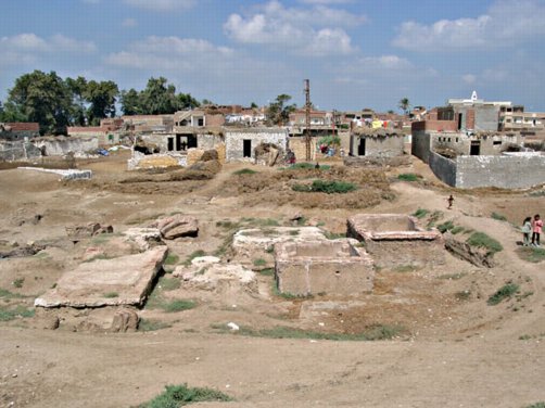
Kom Defshu (SCA 100176) (Map number 8)
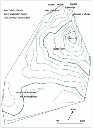
Plan of Kom Defshu.
Click image to view at full-size (requires PDF Viewer browser plug-in).
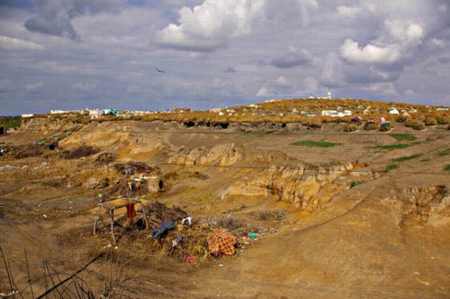
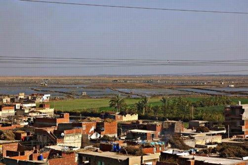
Kom Defshu is a large archaeological area with several distinct zones, but it is mostly obscured underneath a large modern cemetery belonging to the nearby villages of Ezbet Mohammed ed Din and Zinzu. The whole area is at least 530 m from east to west and by 410 m from north to south. The 1:50,000 Survey of Egypt map preserves the name of Defshu only in the canal running nearby.
View from the south-west across the mound with modern cemetery at Kom Defshu. The mosque in the distance is in the village on the north-east side of the site.
The main area consists of a mound sloping gently up to the north-west with a high point of about 10-12 m above the level of the fields and adjacent villages. This area is covered with modern tombs and aloe vera plants. The height of the mound is clear when viewed from the village where it is truncated by a sheer section. The section shows good stratigraphy with layers of pottery, smashed limestone and some cut away sandy brick and mud brick walls. Some of these walls are quite substantial and may represent large administrative buildings or enclosures rather than houses. Their presence implies that the whole mound contains a substantial settlement or specialised complex of some kind, perhaps military or administrative in nature. The mound is most likely to have continued towards the north in the area under the village, so that it was much more extensive, perhaps even twice as large and up to 1 kilometre in length.
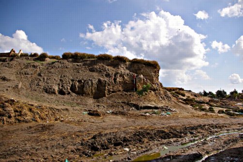
Section of the Kom Defshu mound at the north-west side.
The zone to the south of the cemetery mound is a flat sandy area, maybe about 1 to 2 m above the level of the nearby fields and orchard. It was excavated about 15 years ago for the Egyptian Antiquities Organisation, but no obvious structures remain in the trenches. The surface of the unexcavated portion, however, looks as if there are mud-brick structures here and there are also some red-brick walls traces. In the section at the south-western side there are pottery coffins buried about 1 m below the surface, suggesting that this sandy area of the site was the cemetery area in antiquity. There is human bone elsewhere amongst the surface material.
Drill cores were made in two rough transects across the area of the site in order to understand the underlying geology and position of any river channels. The indications are that the whole site is situated upon a sand hill or levee and the depth of the settlement material and human cultural deposits (pottery and burnt material) suggests that there are different phases of settlement. The upper layers are probably of Late Roman date and are contemporary with the mud brick ramparts at the north-west corner of the tell. Beneath this is a layer of ‘clean’ sand, and then a further settlement layer at a depth of between 5.9 to 7.08 m. The soil here contains burnt material, pottery fragments and some faience, suggesting the possibility that the stratum could be Pharaonic in date.
North of the main mound beneath the fields, there was evidence for deep settlement layers with bone and pottery coming from around ground level, and below this there were also some limestone fragments and pottery going down to a depth of 5 m below ground level where there was a black silt layer mixed with pottery. This material was situated upon the sand and tafl base.
To the north of the mound, the drills cores indicated that there was little settlement outside the immediate mound area and that the local matrix was yellow sand, with some tafl strata.
The presence of broken limestone in both the cores and the sections, suggests that there was a limestone buildings here before the mud-brick structures now visible were built. The limestone must have been broken up for mortar or gypsum powder, or quick lime as was common from the Roman period onward.
Kom Defshu is to the west of the major site of Schedia, which was the port for Alexandria. Defshu could have provided a defensive outpost or town which had existed before Alexandria was founded and into the Roman period. Pottery from the site has been identified as Saite, Ptolemaic and 2nd century AD and confirms the impression that the site may have Pharaonic origins.
Kom el Terfayeh (SCA 100161) (Map number 9)
This site is now subsumed under the village of the same name in this place. It is on the edge of the Idku Marsh area and a series of fish farms. No pottery collection was made here. Two cores were drilled near the modern village in order to obtain information about the marshland and river channels here. The cores showed the presence of the former lake and marsh area to the east, with possible shores indicated by dense shell layers. This area is now a fish farm.
View from the village of Terfayah to the east across the fish farms towards Kom el-Dahab. The new ‘International’ road linking Rosetta and the Alexandria highway can be seen in the distance.Kom el-Dahab III (SCA 100158) (Map number 10)
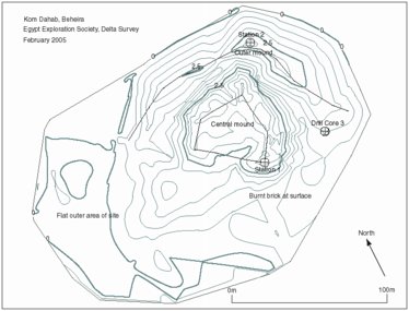
Plan of Kom el-Dahab.
Click image to view at full-size (requires PDF Viewer browser plug-in).
This small mound is located in the fish farms of ‘Lake’ Edku and is visible from the main new road across Idku running from Rosetta to Alexandria. It is shown on the 1:50,000 Survey of Egypt map, but not named. The site is roughly circular, with maximum approximate dimensions of 236 m from north to south and 165 m from east to west. The central mound of is approximately 5 m high with a crescent shaped ridge on the northern side of the site and the surrounding area is either flat or forms the gently sloping sides of the hill. The ditches around the site and some of the embankments around it contain pottery, so that it is likely that the mound is a smaller remnant of a once more extensive site.
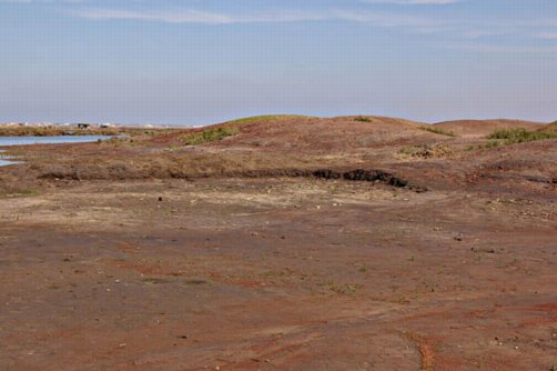
View from the south-east, Kom el-Dahab.
The survey traced the sides of a mud-brick feature on the top surface of the mound and planned a five-sided structure with two pitched sides. This building has an entrance on the southern, long side and the pitched sides face towards Terfayah. It is reasonable to suppose that one side directly faces the town and the river which flowed between the town and this site. The other pitched side may have faced directly towards the sea. The building has a curtain wall in front of it. Some of the low lying structures may be ancillary buildings serving this fortification. The shape of the defensive walls is identical to a fort that once existed at Kom Dikke and two on the Abu Qir promontory called Fort Sab and Fort Tawfiq. The shape suggests that they were designed for cannon and so the fortification is most likley to be Napoleonic or nineteenth century in date.
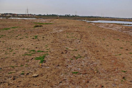
The walls traces on the ground surface. The brown area to the right of the white powdery area represents the wall, a corner of which is marked with the ranging rod.
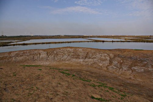
The curtain wall at Kom el-Dahab looking towards the sea.
The whole surface of the mound was covered in Late Antique Roman pottery, glass and bronze coins (mostly very corroded), suggesting that the modern fort was built on top of an ancient site of some description.
The drill cores transect across the site from east to west showed the underlying marsh and river channels in the area prior to the formation of the alluvial mound upon which the present mound was founded. There may have been a pre-existing sand bar or gezira in this location which served as a strategically placed control post for the Canopic mouth of the river. The earlier feature at the site may have been part of the Late Antique defence chain which was later reused for the same purpose, but with a new structure. Alternatively the modern fort may have been constructed from earth brought from a nearby ancient site, such as Kom Terfayah and so the whole mound is redeposited from another place. The ancient material would thus have no context or stratigraphy, but the modern fort would.
Kom Mazen (SCA 100184) (Map number 11)
There is a village called Kom Mazen by the locals, but it seems to be known on the Survey of Egypt map as Bulin. The local people and gafir know of an area of antiquities land said to lie about 1 km to the north of this village. This area is now covered by an orchard and fields. Some pottery is visible lying on the fields and in drainage ditches, but it is not very numerous. The canal running past Bulin is called the Kanoubiya Canal, a memory of the river channel which once ran close to the area. Two drill cores were made in this northern area and both were very similar. After a brief top soil layer, there was alluvial silt from about 0.5m to 3m, and then a gradual change to a sandy matrix with a blue-black colour. A second transect was made through the village of Bulin, starting in a field next to the Kanoubiya Canal. Core 3 consisted of silty alluvium to about 4.5m when it became sandier and darker in colour, with much brown-orange mottling; Core 4 next to the mosque had some modern rubbish on the surface, but then alluvial mud turning to a sandy dark matrix at about 3.5m. This pattern was repeated in Core 5 to the east of the village.
From the evidence of the field survey and cores, it is difficult to believe that there ever was an antiquities area at Kom Mazen. The scatter of pottery in the fields could have come from elsewhere and there is no depth or quantity to any of the pottery in the cores; it is at the surface when it does occur. The underlying geomorphology shows good alluvial land for the last thousand years based on sedimentation rates, and before that sandy soil, perhaps from the sand hills, with organic material.
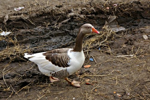
‘Medum’ goose at ‘Kom Mazen’.
Kom el-Qadi (SCA 100165) (Map number 12)
The site is marked on the 1:50,000 Survey of Egypt map as a village Kom Qadi and a mound north-west of the Ezbet Abdu Pasha. There may be some confusion in the naming of some of the sites in the area as there is also a site called Abdu Basha (I) listed by the SCA as 100147. The site visited as part of the survey is now a sprawling area with several distinct zones covering an area of about 370 m from east to west and 170 m from north to south. The main archaeological area is a high mound around 8 m high whose southern and northern faces have been cut away to form sheer sections. The southern sections show sandy brick walls, pottery deposits and human burials in both pottery coffins and brick vaults. Bones of adults and children can be seen in the sections and on top of the mound. This looks like a reuse of the abandoned town mound as a cemetery. On the eastern side there is a substantial mud-brick wall.
Section through the main mound at Kom el-Qadi.
Within the village there is a Roman bath-house which has been restored recently and more chambers can be seen on a sandy area to the east of the village and main mound. A further sandy area lying to the east and a patch of extensive low scrub on the north-east of the village may have been part of the original site.

Kom Qadi with part of a Roman floor and looking towards the main mound.
The mound area could be further investigated and give useful information about the town which once stood here throughout several phases of its use, either by an examination of the sections or by excavation from the top downward. This would at least record information before it is lost and make something of the burials here.
Tell el-Kanaies (SCA 100132) (Map number 15)
This site is in an inaccessible location behind a village. It consists of an area under the village, for example near an old saqiya there was a concentration of pottery sherds and some bone fragments. Further beyond the village there are two low mounds, either side of a canal. The mound nearest the village was used as an a cemetery whose tombs had been almost all removed, except for one empty building left in the centre. A few pottery sherds were noticeable on the ground and a fragment of a quartzite mortar with lug handles was found on the surface. The second mound was a functioning cemetery, with a noticeable set of graves decorated with distinctive tombs. These belonged to the local wealthy family. A fragment of a granite grinding stone lay in the cemetery and lying on the pathway beside the cemetery there was the top part of a granite grinder. A fragment of an alabaster mortar with a lug handle was found in this area.
Mound with abandoned cemetery at Tell el-Kanaies.
Mound with second cemetery at Tell el-Kanaies.
Kom el-Giza (SCA 100154) and Kom el-Hamam (SCA 100156) (Map numbers 16 and 18)
These sites are the location of the ancient port of Alexandria, Schedia, which is well attested from documentary sources. Schedia is under investigation by a mission from the University of Göttingen and the site is spread out over an extensive area, from Al Nashw al-Bahari to Karyun.
There are several distinct zones in the two main areas of the site. At Kom el-Giza: a bath-house, which has been well restored so that its original plan can be seen; a large sandy-mud ridge; and excavated red brick buildings. At Kom el-Hamam: a substantial red brick structure with a number of large square piers with red brick bases and limestone and mortar caps; ridges and mounds of sandy-mud brick structural elements; and a cistern. One of the excavated areas contains grinder -stones made from red granite and black basalt.
Buildings at Kom el-Giza.
Kom el-Hamam view.
Tell Sherif Khalaf (SCA 100136) (Map number 17)
This site is now overbuilt by houses and nothing can be easily seen of the any archaeological material. The highest point of the village is 6 to 7 m above the level of the fields and represents the side of the original mound which was cut off and truncated by the fields on the north-western side. According to the Survey of Egypt 1:50,000 map Ezbet Sharif is in this location, but they do not seem to be visible now. The pottery studied at the site is a collection of Ptolemaic and 7th century AD material.