Saïs Report, Spring 2004
Saïs Report, Spring 2004
Introduction
The continuing work at Sais is funded by the Arts and Humanities Research Council of the United Kingdom and is gratefully acknowledged here. The work in the spring season concentrated on the following areas: (1) the drill augur survey of Sa el-Hagar, (2) completion of the excavation in Kom Rebwa East and study of the pottery and finds from this site, (3) preliminary analysis of environmental samples from previous seasons’ work.
Drill Core Survey
The drill core survey, using a hand augur, was continued from previous seasons in order to cover the area to the south of Sa el-Hagar between the village itself and the mosque of Sheikh Abbas. In all 39 drill cores were completed (from number 118 to 155) and information was obtained about the previous settlement in this area, the river channels and the buried sand gezira. The drilling discovered a layer of pottery and settlement debris in some parts of this area, at a consistent level of about 4m below the ground level, This material, in turn, lay upon the sand bank underlying the floodplain. The buried cultural material implies that the area was deliberately chosen for settlement as, at that time in the past, it was higher than the surrounding flood plain. It is, therefore, a third main settlement area at Sais along with Kom Rebwa and the area under the Great Pit and modern village. The full area covered by the city and its outlying settlements has been extended to around 3km by 1km making it a densely settled area in antiquity, though whether the areas were inhabited at the same time is not yet known. The pottery recovered from the drill cores has not yet been fully analysed and so the date of this material is not known, but earlier indications suggest that some of it could date to the Old Kingdom. Geological evidence suggests that a date between 2000-1000 BC is most likely. Other evidence for river channels was also recovered from the cores, along with some black silty mud which could indicate large areas of standing water such as a lake, harbour area or back swamp. The land here would be a natural place for a harbour, where the river came to the sand bank and then curved around the Sais area (much as the nearby town of Qoddaba has provided a natural landing place for boats and for the control of water through the Qoddaba canal in modern times).
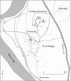 | Map of the Saïs area. Click image to view at full-size (requires PDF Viewer browser plug-in). |
Drill Core Data
The drill core transects show the existence of a river channel around an old sand bank, with settlement focussed on the sand bank. The precise date of this settlement has yet to be determined. A transect further to the east showed very little evidence of settlement remains, but did confirm the presence of a further river channel on this side of the area and matched the data from previous seasons.
| Transect 1 (left) and Transect 2 (right). Click images to view at full-size (requires PDF Viewer browser plug-in). |
Transect 1: The cores in the western part of the transect come down to sand around 4.5m below the ground level (between 5.5-6.5m above sea level). In the cores just south of the modern village of Sa el-Hagar, there were pottery concentrations between 2-3m below the ground level and in Core 141 the pottery and some burnt material (perhaps from a settlement?) was just above the sand level. The central cores 134, 139 and 142 ended at black silt or sand, perhaps indicating the presence of a river channel or enclosed area of water. The Cores 126, 128, 127, 130 and 131 continue to show the underlying sand bank here. In Core 128 there was a further deposit of pottery from the top of the sand bank.
Transect 2: This short transect shows a distinct contrast with Transect 1. All of the cores continued to a depth of 6m or over (except for Core 149 whose sides collapsed) and all ended at the black silt-clay level. This indicated that the sand bank was not in this area or is deeper and buried under the mud. It also suggested that the pottery just above this level indicates either the presence of the settlement further to the south, or that some of the pottery debris had washed down from the sand gezira.
The area south of Sa el Hagar.
The preliminary results from the drill core survey to the south indicate that there are several layers of settlement debris, some just above the sand bank and black silt-clay and that there are some anomalous black silt-clay sediments enclosed by the sand bank. Though the surface pottery levels are most likely to be modern or non-stratified deposits, the pottery deposits buried 3-4.5 m below the level of the modern field systems suggest that the area here was settled in antiquity. Future work in this area, both by drilling and field walking survey will make the picture clearer.
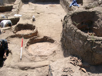
Excavation in Kom Rebwa East.
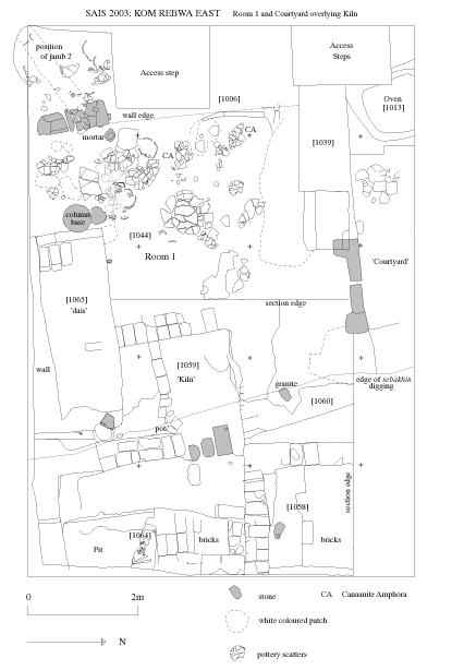
The excavation in Kom Rebwa, begun in 2000, was continued and finished this season. Several phases of settlement in this area were determined, mostly within the Late New Kingdom to Third Intermediate Period, but good pottery evidence for an Old Kingdom settlement was also discovered. The excavation concentrated on the areas of ‘Room 1’ and the ‘Courtyard’ of the building from 2001-3.
The floor of Room 1 and the area adjoining beside the south-western doorway had been covered in pottery. All of this material was removed and the layers of the floors were carefully removed. The floor layers were deep and consisted of layers of white decayed organic material, deposits of chaff (green and white), burnt pink-ashy material, sand and pottery crushed onto each succeeding floor layer. It was difficult to separate individual layers, but the floor had been refurbished and cleaned several times with the addition of floor coverings of either clean sand, reed matting or white gypsum.
When the lower layers of fill were removed a foundation trench and mud brick foundation for the wall [1006] to the west of Room 1 was noted. The building had been founded on an area which had been especially prepared by dumping fill and mud-brick rubble to create a relatively level surface, then, the mud brick layer had been laid and the wall built upon it.
Some small finds as well as pottery came from the floor fill including: small faience ring and spherical beads, a limestone stone disk and cow horns from a statuette, fragments of pottery cobra figures, a friable faience wedjat-eye, flint blades and sickle blades, necklace elements suchs as fragments of carnelian beads and faience poppy head pendants.
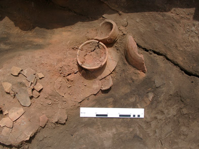
The ‘Courtyard’ area had a similar dense concentration of activity, with several floor layers upon the foundations of the walls of this area . The wall [1039] through which had been the main entrance to Room 1, had been founded almost directly upon an oven [1086] from an earlier phase of use. This oven was contemporary with a second oven [1085] under the Courtyard.
Both derive from a phase when this northern part of the trench was more used than the area to the south (which contained brown fill). It probably represents a domestic area contemporary with the Kiln [1059 and 1092]. The two ovens had been used and the burnt contents from them thrown out into the area around them. This area was refurbished several times by the construction of ephemeral yellow brick surrounds and floors for the ovens. They seem to have been primarily bread ovens, as a number of bread moulds were found here, along with bread trays and beer jars. The final form of the ovens is unknown but they had slightly concave sides and may have had inturned rims. They were founded on solid bread tray fragments and rough, unfired mud filling was placed in the bottom of the ovens.
Wall [1039] was removed in order to understand the sequence for the Ovens [1086] and [1085]. The small finds from the ashy fill included a ring of an unknown metal, faience and glass beads and an ivory stud or knob from a box . A statuette fragment was also found in the fill of a small pit. It comes from a figure of a woman (?) striding with the left leg forward. The person was wearing a pleated gown, with a fringe down the side of the leg. This type of garment is well known on the costumes of people depicted on stelae of the Third Intermediate Period and so the statuette may have dated from this time. Though the fragment has parts of some hieroglyphs, not enough survives to provide a full inscription.
Oven 2 [1013] associated with the functioning ‘Courtyard’ was excavated completely and found to have a diameter of 1.70m by 1.60, and a surviving depth of 0.70m. It seemed to have been for general cooking purposes as the contents of the oven consisted of bowls and plates of various kinds. The construction of this oven showed that it had a burnt pottery internal structure which had been covered with mud bricks and mud and fragments of a pottery lid were found in the fill. The external covering of the oven may have helped to retain the heat of the oven and is quite different from the two ovens found underneath in the lower phase. These ovens had a completely burnt pottery outer structure set within a sandy mud brick area. It is likely that this reflects the different uses of the ovens. The ovens with the mud-brick and internal, fired structure being used for cooking and heating of food inside bowls and vessels, while the pottery ovens were used for bread making both in moulds inside the oven and by placing the bread on the outside, like a tandoori oven.
Kiln: the kiln under the floor level of Room 1 to the east of the trench had been partially excavated in 2003. It was completely excavated in this season and found to consist of 3 main rooms. One contained two small amporiskos vessels, in a fragmentary but complete state, some red faience spacer beads, a number of other vessels and burnt flints. The kiln seems to have been used for firing pottery as several over-fired examples and wasters were found at floor level. The two small vessels, an amphoriskos (small amphora) with torpedo shape and jar with flared neck probably date to the Ramesside period. The brickwork of the kiln showed evidence for a great deal of burning. A second chamber contained fragments of a pottery weaving bowl, a funnel, pumice stones and other vessels. A third chamber contained an almost complete vessel and fragments of others.
The roof of the kiln may have collapsed while the kiln was in use and this event may be connected with a large fissure which ran through the structure and beyond into the trench. During an earthquake or subsidence, the structure may have been damaged. ‘Room 1’ was directly over this area.
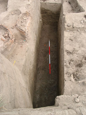
A test trench was dug to a maximum depth of 3m from the ground level east-west across the trench to show the depth of settlement deposits at this part of the site. The groundwater level was not yet reached indicating the potential for intensive excavation in the Kom Rebwa area to establish the nature of the mud brick structures and settlement remains.
Beneath the excavated areas dating to the New Kingdom and Third Intermediate Period (according to the pottery dating) there were several main phases of construction. The most immediate lay directly under the Kiln phase and was a large mud brick wall. Under Room 1 there were directly three main building phases: a substantial wall or foundation at a level of 0.2m, a second wall at 0.3-0.9m, a third wall at 1.0-1.5m and a lower section of fill or settlement debris containing Old Kingdom pottery material from 1.5-1.8m. All of the walls were built of a mixture of sandy and grey-mud bricks. The lower wall seemed to have been founded upon a layer of dark brown mud, with grey-blue mottling which contained a large amount of polished pottery.
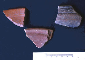
Some of this is Old Kingdom in date, consisting of distinctive bowls with orange slip and high polish. This small layer of pottery has produced more fine wares than the whole of the Late New Kingdom area, where domestic bowls, amphorae and bread trays are most common. The Old Kingdom material was mixed with New Kingdom material, confirming that it came from fill being re-used for the foundation platform of the large wall or structure apparently running north-south under this part of the site. The pottery from the intervening phases was kept for later analysis.
Small finds from the test trench included flint blades and sickle blades, blue painted and other decorated pottery, fine-ware pottery, burnt animal bones, a haematite weight or amulet fragment.
The results suggest that there are up to 4m of stratified settlement layers, probably dating to the New Kingdom onwards and into the Third Intermediate Period. The kiln is most likely to be Ramesside in date, the Room 1, Courtyard and Oven complex is from the Third Intermediate Period and the small structures above this, excavated in previous seasons are probably late TIP. A substantial Old Kingdom settlement was also once located here, perhaps in this same area. The lack of any evidence from an intervening Middle Kingdom phase is interesting. An object found used in the rubbish and fill of one of the foundation structures, seems to resemble a soul house, which are typically associated with the Middle Kingdom. They do, however, begin in the late Old Kingdom-First Intermediate Period and so may belong to this phase.
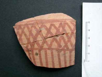
Good progress was made with the reconstruction of amphorae from the amphorae dump to the south-west of the ‘Courtyard’ area [1051], so that some of the vessels could be drawn. The following vessels were drawn: a white slipped large globular jar, a Syrian amphora, a Canaanite amphora, the weaving bowl, funnel, large red jar, pot-stands and smaller beer jars. Good progress was also made with the drawing of diagnostic sherds and vessels for the Sais pottery corpus.