Saïs Report, 2001
Saïs Report, 2001
Work continued in two seasons in spring and summer this year.
Spring Season
The team worked at Sais from 21st March until 9th April. The mission consisted of Dr Penny Wilson (Field Director) and Mr Duncan Hale (Geophysicist), both of the Durham University, with Ms Fatma Rageb Kamel as SCA Inspector.
Introduction
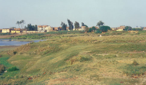
Altogether about 9 hectares of fields were surveyed with a fluxgate magnetometer in twenty Areas with a variety of results. On the whole it was impossible to survey fields with pronounced irrigation ridges already set out, as the ridges gave the data a stripy effect and virtually swamped any other less visible data. Some fields had been ploughed once leaving large clods of earth which were difficult to walk over. As a result the best fields were either (a) ‘dead’ land, that is land which was too poor for cultivation because of excessive salt in the soil, or simply with poor soil (b) fields which had been ploughed but then flattened prior to putting in ridges (c) newly cropped ‘bursim’ fields where the stubble was short and surface fairly even (d) flat areas in Kom Rebwa and near the Great Pit.
Results
In general it seemed that the further away land was surveyed from the current Antiquities land at Kom Rebwa and the Great Pit, the less there was to find under the ground. Bearing in mind that the maximum depth of penetration of the magnetometer is about 4m, it is possible that any archaeological remains may have been buried under alluvial mud, ploughed out through intensive agriculture, or buried under successive additions of manured earth brought from elsewhere to the fields. Therefore Area 1 outside and to the north of the Enclosure was very featureless.
There was good coverage of the north-west area of the North Enclosure from the corner moving eastwards. The corner area has always been ‘bad’ land and though attempts have been made to grow crops here they have always seemed to fail since the beginning of the Sais survey in 1997. A large area was therefore surveyed and again found to be without significant anomalies. Again, during the nineteenth century it is clear this area was flooded each year with the inundation having broken through the Enclosure walls, so that any remaining monuments here may have been washed away or buried very deeply. Some ditch features were found which may be worthy of future study.
Further towards the centre of the Enclosure occasional faint anomalies showed up in a couple of areas. Some of them could have been old field boundaries, water channels or other agricultural phenomenon and some could be ditch-like archaeological features.
On the east side one bursim field against the Eastern Enclosure wall was surveyed and proved to have a possible 4m wide ditch across it filled with material which showed up as an intense anomaly (possibly pottery).
Between the Enclosure and the Canal only two areas could be surveyed: one in the very centre point of this zone – a large field here showed no anomalies at all; the other was a small area almost at the apex of the trackways, however it was an irregularly shaped field around a house and contained much rubbish and electricity pylons. The data from this area was not very good and it was difficult to make too much of it.
Fields between the two parts of Kom Rebwa showed anomalies and looked promising. No clear cut features could be identified but there may have been traces of ditches and past massive disturbance of the soil. The clearance of these fields was frustrating because it went so slowly and they were in an area with archaeological potential.
A field directly to the west of the Sheikh Shaheen farmhouse was surveyed and found to be quite clear which was surprising because of its proximity to the field containing a large building surveyed in 1998.
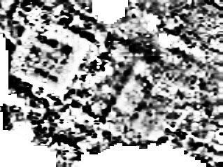
The best results came from known archaeological areas. In Kom Rebwa east we had not surveyed any of this part of the site before because of the hilly nature of the landscape and the long grass which concealed many dog burrows and other excavated holes. This year we decided to try to see what kind of data could be gathered. The survey started on the west side of Kom Rebwa next to the main track and there seemed to be little hope for the results because of the amount of modern rubbish, including chunks of brickwork and metal tins which had been disposed of here. However, the data suggests that there are clear archaeological features here under the debris, possibly a limestone wall running under the main area of the Kom.
The only remaining area of clear unexcavated land at Sais between the village and the North Enclosure is a small area to the north-east of the Great Pit. Usually in the summer this land is very marshy because of water run-off from the rice fields, but in March it was dry so we were able to survey it. In the area between the granite torso and a pit there is a 20 metre square limestone or mud-brick walled building with interior walls and possibly large stone objects lying outside it. There are other linear features too in this area, suggesting that excavation in the 1960s by the EAO were not completed. In fact the area of the building could actually be seen on the surface where it showed up as much saltier earth among the grass.
The lack of water in this northern side of the Great Pit also allowed the lower part of the area to be surveyed. This was a quite extensive area, but lying at or below the Saite temple foundation level. It was quite surprising to find a major pit or ditch under this area and also a number of other ephemeral anomalies. Whatever they are they either date from the destruction of the site and are pits filled with debris, or are earlier archaeological features (the PD material on the west is only 2-3m below the ground surface).
Other Work
Penny Wilson checked plans of standing monuments for inclusion in The Survey of Sais volume, checked notes made for the section on the topographical survey, checked survey points and also photographed the small finds and some pottery from last season. She also spent more time in the Tanta archives.
Summary
Despite the relatively negative results from this survey, it does help to fill in the archaeological map of the area and a fairly large area was covered. It was disappointing not to be able to survey any fields to the west where there could have been a harbour, and on the east in the vicinity of the so called ‘Road’ to Kafr Hammam.
Nevertheless the magnetometer has proved its worth as a recorder of information. The challenge lies in the interpretation of the data and in being able to pick out limestone walls, hearths and other features amongst the mass of information. There was a useful correlation between the Area J surveyed in 1998 and the excavations of the SCA in this area while we were here. This enabled us to see exactly how the data had shown up certain features and will be of great use in the interpretation of all our results.
Acknowledgments
Thanks as always are due to the Inspectorate at Tanta for facilitating the work and their keenness to promote the work. I would especially like to thank Mr Abdu el Fatah and Mr Abd el Ghrainy Zaki for their help and patience. Our Inspector Fatmah Rageb Kamel not only encouraged us but translated old reports and Register books in the Tanta Archives, making an original contribution to the Mission. The people of Sa el-Hagar looked after us supremely well with their customary kindness and hospitality. Thanks are due too to Rawya Ismail in Cairo for her unfailing help and enthusiasm. I would also like to thank Peter Carne of Archaeological Services, Durham University for loaning us Duncan Hale and his expertise.
Penny Wilson,
Sa el-Hagar, 9th April 2001
Summer Season
The team was in the field from 15th August to 22nd September 2001 and consisted of Dr Penny Wilson (Field Director), Gregory Gilbert, Nicola Midgely (Archaeologists), Dan Lines (Drill Core Supervisor), Amélie Roland-Gosselin (Illustrator), Drs Sylvie Marchand and Catherine Defernez (Ceramicists), Fatma Rageb Kamel (SCA Representative).
Summary of Results
- Excavation 3 on western edge of Great Pit, showing Buto-Maadi culture settlement (ca. 3500 BC), with analysis of pottery (including Upper Egyptian imports, burnished wares, embossed decorated wares) and lithics. The bones were from a wide range of animals including pigs, cattle, donkeys and maybe antelope.
- Drill Core Project continued in and around the village and in the Northern Enclosure. The latter showed dense settlement in this area in several strata and clear Old Kingdom pottery at some of the lower levels.
- Excavation 1 at Kom Rebwa east continued. The analysis of the pottery shows that the Ovens and associated buildings are Ramesside in date with the top strata of destroyed material containing Late Ramesside to Third Intermediate Period pottery with some intrusive (?) Dynasty 18, Old Kingdom, First Intermediate Period and Saïte material. A large building with 2m high limestone door jambs and threshold stones was discovered.
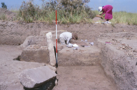
Excavation 3
For the first eight days intensive excavation work was carried out in a 5 by 5 metre square trench on the western side of the Great Pit (Excavation 3). The area is next to the test trench dug last year in order to find Predynastic material. This year the aim of the work was to find some sort of context for the material in order to assess its exact nature. As the Predynastic layers were not too far from the surface the excavations proceeded carefully, but intensively because of the sand/water level problems encountered last year. In the event, good results were obtained using a smaller sump than last year which was baled out at regular intervals. At a level of about 2m the water became uncontrollable by this method and though the Predynastic levels may still have continued, Predynastic settlement and occupation strata had been
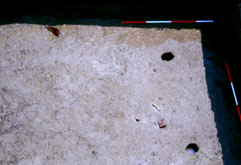
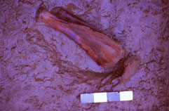
The latest contexts were Ptolemaic and Dynasty 26 material in a pit probably dug at the time of the destruction of Saïs. They formed a thin, upper disturbed level at the top of the trench. Below this level at about 1m, the strata contained a sloping sand hill with Predynastic pottery. However, we believe that this context is not a settlement level but is somehow due to the properties of wet sand which may have drawn up the material from lower down by capillary action. A settlement level was found lying underneath this sand hill, which may have been wind blown or redeposited by water action from the nearby gezira. The settlement material contained bones of animals, charcoal, and quantities of pottery. The basic matrix of the context was brown-orange in colour which indicates decayed organic deposits with occasional black streaks perhaps caused by standing water with plants growing in it or charcoal deposits.
Initial examination of the bones suggested that a wide variety of animals were present, including bovids (large pieces of jaw bones, scapula and vertebrae), pigs (both juvenile and mature females), caprids, donkey, antelope and synodontis fish.
Two main separate settlement contexts were found, interleaved with each other and with sand episodes. This may suggest either seasonal occupation or unstable natural environmental conditions. It also seems that these settlement contexts may be on the side of a sand hill as has occurred in other delta sites such as Minshat Abu Omar and again suggests that settlement areas were mobile depending on the Nile floods and river channels, so that they effectively moved as allowed by the river.
The context of the deposits however show little pattern and though one clear post hole was found, a number of others could not be substantiated, nor was it clear if there were hearths. It is also suspected that at least one context was washed down the sand slope forming a band around part of the hill. In this case there is the possibility that some of these layers are actually redeposited and not in situ settlement material. The contexts are therefore somewhat complicated and so far open to varying interpretations, but none the less welcome for beginning to formulate some ideas about early Saïs.
In all about 5300 sherds were collected, and, although this cannot really be said to be a statistically representative sample, it does have some merit. Many of the sherds were very water-worn and eroded and after removal from the ground many started to decay due to salt action. The actual layers of material were at most 15cm thick and the whole area fairly small. However the choice of places to dig is extremely limited and with each square the area of ‘Predynastic Real-Estate’ is drastically reduced. Mindful of this we did not open another square, though the area is expected to be built over in the next few years. It may be possible that future work can be carried out to answer some of the questions from the material so far found once the data has been processed.
The date of the pottery seems to be ca 3500 BC and conforms to Maadi-Buto culture types. There are some imported Upper Egyptian sherds, but apparently no Syro-Palestinian sherds (because it is too early). So far any evidence for the later PD stages have not been found and it is likely that in fact the material from Excavation 2 found in 2000 is also of this date, rather than being Nagada III date as originally suggested.
Four main types of pottery wares could be distinguished:
- Straw tempered Nile Silt
- Untempered Nile Silt (many burnished and including a few UE imports)
- Coarse straw tempered Nile Silt (bread trays/moulds)
- Coarse straw and stone tempered Nile Silt (bricks ?)
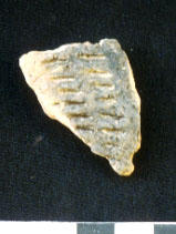
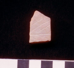
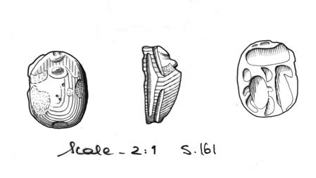
The pottery forms consisted of rounded bowls with inverted rims, bowls with modelled and ledged rims, closed jars, necked jars. Many have black soot on the surface from use in cooking. The main method of decoration was burnishing, but there were a few sherds with rolled or impressed horseshoe shapes or small marks and one sherd had an incised leaf or tree motif.
Among other finds are a number of red and yellow quartzite stones, small white quartzite pebbles, microblades and a few irregular flint blades and one possible moulded bull horn in pottery.
Drill Cores
The drill core work continued unabated and altogether about 30 cores were completed this year giving a total of 86. Work was concentrated in the Northern Enclosure, an area with a complex occupation/settlement history and possibly several sequences of intensive settlement. It was pleasing to find that there several layers of settlement debris and that among some of the lower levels there were recognisable Old Kingdom sherds. This suggests that Saïs has considerable archaeological strata and while all of them may not be easy to recover, the longevity of the site has been proven. It seems possible to recognise settlement areas and maybe date them, which may lead to a detailed archaeological map of the whole area.
Far from being a later development at the site the Northern Enclosure does seem to be an anciently founded city and, remarkably, little evidence has been found from the coring of significant deviation from the established Enclosure wall.
Two transects were made within the village of Sa el-Hagar and to the south to try to establish the archaeological material in the tell. Inevitably in an occupied site it proved very difficult to drill to any depth, mainly because the older houses in the village have red brick foundations and they cannot be penetrated by the drill. However one old house in the village was being demolished and a core was made in its foundations even though it was not high up on the town mound. This went to a depth of about 6m when it was stopped by a stone. The cores made to the west of the village by now produced consistently predictable material with sands directly on the west of the village and mud coming down to blue-black sandy clays further to the west charting the old course of the river on this side of the village.
Excavation 1 – Kom Rebwa East
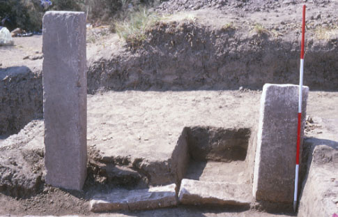
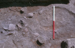
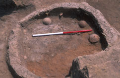
Limited excavations were continued in this area and the work here has not been completed. The main reason for this was that Oven 2 from the western side of the site, proved to be a substantial feature 1.5m wide by 1.5 deep and full of pottery. Some of the vessels were found in a complete state, others were already fragmentary. In view of the massive amounts of sherds it was considered to be better to process the material ready for study next season rather than dig up more and be completely overwhelmed. In addition, in the southern half of the trench a door way was discovered leading into a room or building whose walls proved to have collapsed on the west and to have been dug into on the east, thus being difficult to define. The doorway consisted of two limestone door jambs, one fallen jamb was 2m high by 40 cm wide with a huge bolt-hole on the back and the other had been cut in half, but was standing in situ. Unfortunately, neither was inscribed. At the base of the jambs were two threshold blocks leaving an entry space of 2m wide. In the eastern part of the trench, a sand trench was excavated and directly underneath it a layer containing large circular oven remains. This seems to be the lowest part of our excavations and it still does not contain water. The Excavation 1 trench therefore seems to be a slice through Saïte stratigraphy, with a difference of 2m between top and bottom and the material in between is all stratified archaeological deposit. This is of course just one 10 by 10m trench in an area of about 120,000 m2, and it seems to contain maybe store or magazine buildings with dense production and manufacture areas. The archaeological potential of the site is thus enormous and is further amplified by the dating of the pottery from this area.
In trial sherd sampling in 2000 in various parts of the whole site, areas of Early Saite sherds were identified, along with Roman Pottery dumps. Sylvie Marchand and Catherine Defernez recognised that the material from the top disturbed strata in Excavation 1 dated from Dynasty 18 through the Late Ramesside to Third Intermediate Period. After looking through the material from 2000 they concluded that there were a few intrusive sherds of Saite material, along with First Intermediate Period and Late Old Kingdom pottery. The bulk of the pottery was Ramesside and Third Intermediate Period. The stratified material from the Ovens 1 and 2 is Ramesside in date. Though not yet fully studied the indications are that the pottery from the building may be Dynasty 18 in date and the pottery from the eastern side sealed under the sand pit is Old Kingdom in date. This date range is a surprise and suggests that any Saite material may have been completely removed or that the area under excavation was in use until the Third Intermediate Period and then maybe abandoned. The top redeem (rubbish) layers are very mixed indeed and may be sebakhhin dumps, or simply top strata of soil which has been eroded and are therefore gradually accumulated thick layers of sherd material. As the nineteenth century descriptions indicate considerable ruins once existed at the site and may have formed a proper tell with many layers of occupation. These have been largely removed leaving the earlier buried archaeological strata.
The Old Kingdom material includes ‘Medum Bowls’ and red burnished pottery and the First Intermediate Period is represented by hand-made bread moulds with distinctive base spikes.
The ceramic team began a system of Fabric classification giving a preliminary system of 10 Nile Silt Fabrics and 11 Marl or imported clays. A pottery typology was also begun containing 152 forms spread over six Strata and including some Cypriot imports.
Finds aside from pottery were rare but there continued to be the terracotta cobras (which may match the dates of those recently published from Memphis and found at Tell Abqa’in), gaming pieces, flints blades (including a fine sickle blade), smashed fragments of worked stone including one with a single hieroglyph, bone (sheep, cattle, dogs, donkey), bone pins, small pieces of copper alloy, yellow ochre and in the fill a faience scarab apparently with the signs for ‘Men-Kheper-Maat (or Re)’.
The archaeology of this small area is complicated because of the nature of the settlement here. It has several phases, with small walls being built against more substantial structures and the later ovens apparently cut into the side wall of the large building. It therefore reflects the more organic nature of settlement sites and also seems to be part of a complex containing maybe large official storerooms or magazines and food production areas.
Area Survey
A number of villages in the Sa el-Hagar area were visited in order to assess their archaeological potential as old satellite towns of Sais. Though some proved to be very interesting and old, and stood upon small mounds it was difficult to gauge their age as settlements or any underlying archaeological material. However Ganag and Najrijj have old quarters which were historically and ethnologically interesting, and the latter is built on a small but significant mound, Bahr al-Hamam had some uninscribed granite and brown quartzite blocks re-used in the town, Kom Abbud and Ezbet al Kom al Abyad have nothing visible but En-Nahhariyyah proved to have the most to see. Labib Habachi published 19 inscribed blocks he saw here (ASAÉ 42) and suggested that they had come from Sa el Hagar originally. We found five of them built into the mosque of Mohammed Ibn Zein where Habachi had seen them, but the fact that most of the mosques seen in the villages have been very recently rebuilt suggests that unless the inscribed stones are removed they will be incorporated into the fabric of the buildings. The chance nature of these visits was demonstrated when we went for tea at the house of our taxi driver in Mehallat al-Laban. There was a fragment of a statue base with a human foot built into his entrance.
A number of modern pottery workshops in the area were also visited.
Acknowledgements
Thanks are due to the French Institute and current Director, Nicolas Grimal, for allowing Drs. Marchand and Defernez to work with the mission and to Gregory Gilbert for his continued support and interest in the work. As always, the Tanta Inspectorate under Mr Abdel Fatah facilitated the work in every way possible and the police and guards at Sa el-Hagar were helpful and friendly as usual. I would also like to thank Senne el-Bishe for running our dig house and Ashraf el-Bishe for letting us overrun it.
Penny Wilson
Sa el-Hagar,
18th September 2001