Saïs Report, 2007
Saïs Report, 2007
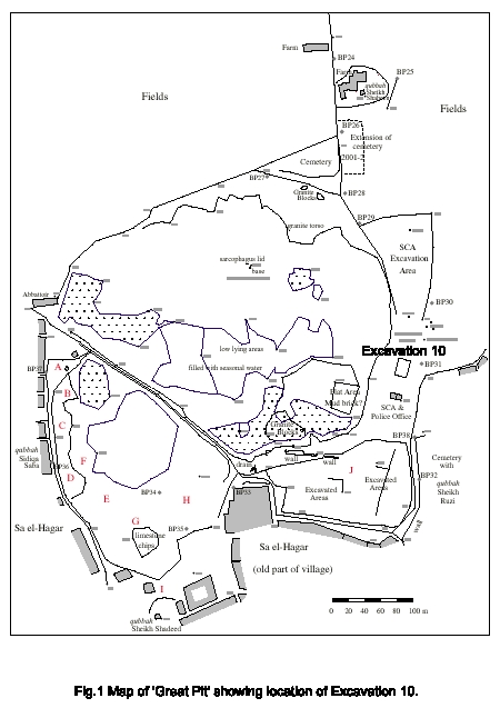
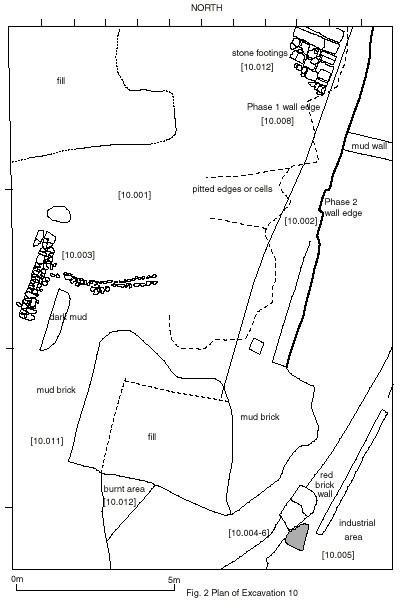
Excavation 10 : Excavation for a Magazine Building at Sais
A key part of the Sais project, supported by funding from the Arts and Humanities Research Council, was the creation of a dissemination project at Sais. It was decided to build a storehouse magazine/display area which would show what the work of the Mission had achieved and also house study collections of pottery and fragmentary small finds. Permission for the magazine was granted by the Supreme Council for Antiquities and an area next to the current SCA rest house was chosen as the site. Before any building work could be undertaken, the area had to be excavated in order to investigate its archaeology. Accordingly, in Spring 2007, we carried out Excavation 10 on the area chosen for the magazine/display centre.
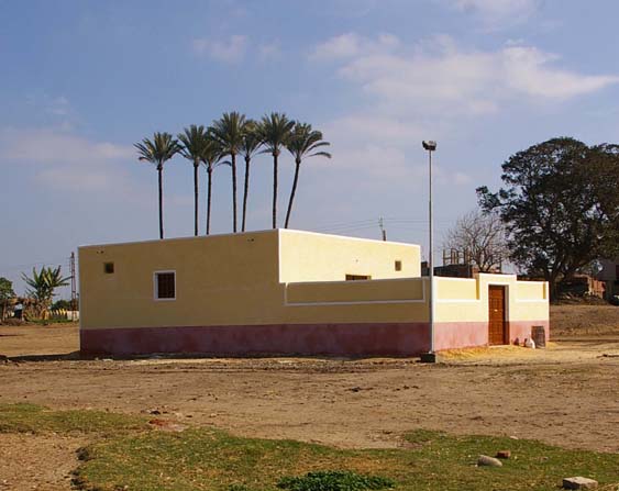
With the construction of the Magazine itself in 2007, we were able to set up Display boards detailing the history of the site and the work of the EES/Durham Mission there since 1997. The boards are in both English and Arabic. They are printed out on plasticised fabric, rather like plastic tablecloths, but this is ideal for the dust, dirt and occasional dampness at Sa el Hagar. The sheets are framed to keep them rigid and can be easily moved and hung inside the building, outside the building, or perhaps in other places. It is hoped that in 2008 they will be on show at the magazine and in the village of Sa el Hagar.
Excavation Work :
Introduction
According to the regulations of the Supreme Council of Antiquities, a test excavation was carried out in the area selected for the building of a magazine for the Durham University/EES Mission to Sais with funding from the AHRC. An area of 17m by 12m was laid out to provide the foundations for a 11m by 16m building, as proposed by the Mission, in an area chosen by the SCA, on the eastern side of the ‘Great Pit’ to the north of the Antiquities Office/Sa el-Hagar Police Station.
Click image to view at full-size. (Requires PDF Viewer browser plug-in.)
The area was surveyed using a magnetometer by the Durham/EES Mission in 1998 and the results of the geophysical survey seemed to suggest that there was some kind of linear feature in this area which appeared as a thick white line running from north-east to south-west. It was not clear whether this was a recent ditch or an archaeological feature. In addition, there was a mass of dark anomalies to the south-west suggesting dense pottery concentrations. Visual examination of the ground surface showed that there was a great deal of pottery at the surface which could have been obscuring other, deeper features.
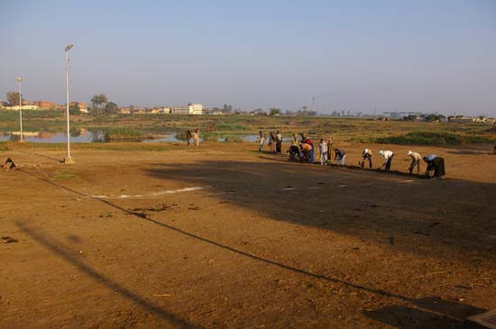
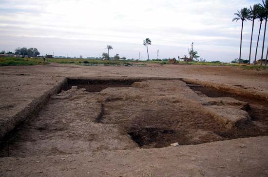
Starting work on Excavation 10.
The excavation number follows on from the excavation sequence of the Durham University/EES Mission. All contexts are therefore prefixed by 10.
Click image to view at full-size. (Requires PDF Viewer browser plug-in.)
The upper layer [10.000] was a compacted layer of ancient pottery, some modern rubbish and was very hard and dense. The upper stratum of the trench [10.001] was immediately below it. It comprised a layer of thick earth fill, with pottery in some very dense concentrations, as well as fragments of broken limestone, burnt limestone and some broken granite and orthoquartzite fragments. Most of the pottery was broken and appeared to be have been dumped into pits or in mounds, so that it was unlikely to have been lying in its original position where it had been left.
Most of the fragments of pottery seemed to be from amphora, including locally produced types as well as imports. There were some domestic cooking vessel, water jugs and larger bowls or plates. There were very few fragments of fine wares. There were also fragments of glass vessels, which had survived well in some cases, but almost all showed iridescence and disintegration of the surfaces. As far as it was possible to tell, the material most likely dated to the 4th century AD, that is the Middle-Late Roman period.
When the surface was cleaned a light coloured mud stripe showed up at the surface which ran from the north-east corner of the trench to the south west and an area of red brick debris and parts of a wall were visible in the south western corner of the trench. These two features proved to be the most distinctive upper archaeological features.
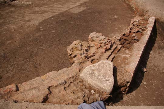
The Mud-Brick Walls [10.002 and 10.008]
View from south of mud-brick wall and pitting.
The mud stripe was the eastern edge of a substantial mud-brick wall running through the trench which had been built from bricks measuring 35 by 17.5 cm. The bricks consisted of both grey mud and also lighter brown coloured bricks. The western edge of the wall had either been eroded away or deliberately pitted and then the pits filled with dense concentrations of broken pottery rubble or the wall may have been constructed as a series of retaining mud-brick walls creating cells or ‘rooms’ which were then filled with rubble and broken pottery. In this case the mud brick wall could post-date the pottery and be of Late Roman date or it could be an earlier Roman structure which had been modified and repaired through use.
The southern end of the wall was less easy to see, as it seemed to have been very pitted, and it was unclear whether it had continued through the trench to the south. This wall was recorded and then removed in order to obtain information from the wall foundation trench.
The foundation trench was located and appeared to contain Ptolemaic and some Saite pottery. It seemed that the wall [10.002] had been built upon an earlier structure [10.008] which was narrower in width. It seems that the later wall had been around and on top of the earlier structure enclosing it inside it.
At the northern end of the wall [10.008] there were some limestone footings which may have been intended as part of an entrance or corner of this wall.
[10.012] Stone footings
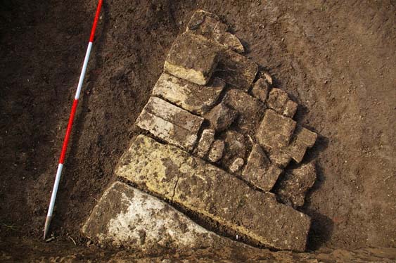
Stone footings. South is at the top of the picture. The ranging rod is 2m long.
The stone footings consisted of a group of reused fragments limestone which had been fitted together like a rough jigsaw. There was one irregular granite block amongst the fragments. Some of the limestone blocks had roughly worked flat sides and some had cut back areas, and shaped features. There was one square block of stone lying on top of the main group of stones which may have been the base of a door jamb, or perhaps was simply part of the second course of stones. It had worked sides and a small pediment running along its eastern side. The mass of the stone blocks formed a triangular end to two larger rectangular blocks which seemed to continue under the section to the north. They may be part of a much larger stone structure such as a wall. The form of these stones — long and narrow — resembled some of the stones used in the limestone wall at the southern edge of the Great Pit. The eastern edge of the footings was aligned with the line of the mud brick Phase 1 wall running to the south west.
[10.003] Retaining stone wall
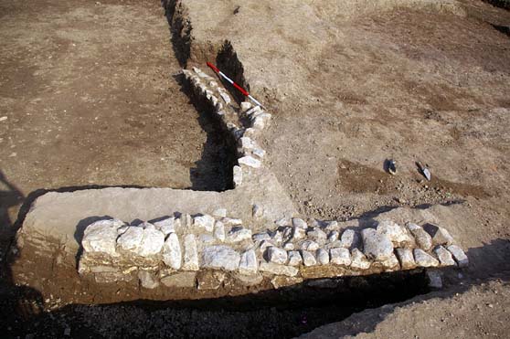
The stone wall. View towards the east. The ranging rod is 2m long.
The western edge of either wall was difficult to determine because of the amount of disturbance and pitting of the wall, but it is also possible that the wall was so wide that the edge was beyond the trench to the west. However, a small rough stone wall was found on the western side which may have been the edge of the Phase 2 wall a acting as a strengthening retaining wall or as a repair for the wall. Most of the stones used to construct the wall were irregular but there were some blocks with straight edges. The wall comprised at least three courses in the main section. A more ephemeral series of stones ran to the east away from the main structure. They were buried within the mud brick and again may have been acting as a repair to keep back damaged or eroded areas of the mud brick wall.
Summary of the wall: in Phase 1 a mud brick wall was built using 35×17.5cm bricks which had an entrance or formed part of an even older original structure from which a series of stone footings were preserved. This wall had then been enclosed in Phase 2 within a later wall, which had been substantially pitted or built as a cellular structure with some dry-stone wall structures acting as retaining walls for the cells in places. The interior of this cellular structure had been filled with pottery and broken stone debris. It may extend further to the west where a series of pottery and rubble filled cells are visible on the ground surface.
The width of [10.008] was not determined for certain. The foundation wall for this building [10.009] seemed to contain pottery which may have been Ptolemaic in date and also had some pieces of Saite pottery mixed with it. It may therefore have been built on top of an even earlier structure from which the stones had been reused.
The width of [10.002] was approximately 3.30 m, judging by the edge of the wall and the retaining wall [10.003]. This is not substantial enough to be an enclosure wall, but it may be the outer wall of a large building or foundation structure which may account for the mass of rubble and debris inside it.
The Red Brick Structure [10.004 becoming 10.006]
Red brick structure. North is at the top of the picture.
A dense area of red brick was located in the south-east corner of the trench. It comprised a straight outer wall which was plastered on the outside with a curving, more substantial wall on its western side which continued into both the eastern and southern sections. After a rain storm the red brick wall could be further traced on the southern side of the trench at the ground surface. It seemed to be part of a much more substantial building.
The two walls had collapsed and been damaged at the top, but the area between them was filled with brick and pottery rubble and a large limestone rock which may have been used as a supporting foundation.
Approximately half-way along the curved wall there was a lump of brick rubble for which it was difficult to discern any shape. It had been at the surface of the trench and may have been part of the red brick wall which had fallen away inside the building. When it was cleaned the brickwork looked a little more regular as if it were the base or footings of some other feature perhaps a column or vault springing. It was still very rubble-like though so this is not a definite conclusion.
The wall had been constructed of a mixture of rectangular red bricks and some square red bricks and pink mortar had been used to hold the brick work together. The curved wall seemed to have been made in sections with as a rubble filled structure with bricks used to flatten sections and retaining bricks used to keep the cells in place.
A test pit was dug beside the wall on the inside to determine its depth at the end of the season and the wall was found to continue to a depth of at least another 60cm to below the ground water level.
On the inside of the wall there was a large vessel embedded in the rubble which had impressed decoration around the top. It was left in situ as it would require more considerable excavation to remove it.
In the south-east corner of the trench outside the red-brick building was an industrial area [10.005] displaying signs of burning. This contained a group of Late Roman amphorae with long, ribbed necks and wide bodies, as well as some other imported amphorae.
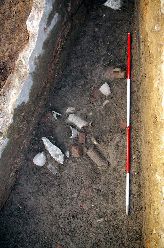
Amphora dump. North is at the top of the picture. The ranging rod is 2m long.
There were also noticeably more fragments of faience in this area and some faience slag. Some of the faience dishes, cups and plates had turquoise and black glaze decoration. It was collected as a group for later study.
Summary
The red brick structure is part of a much larger building which runs into the corner of our excavation trench up to 7m along the eastern side and 5m along the southern side. The curved wall inside a straight retaining wall and the possible presence of a vault springing may suggest the possibility that this is part of a church building. The industrial activity outside the buildings may also strengthen this identification as churches were centres of production across North Africa into the Later Roman period.
The relationship between the red-brick building and the mud brick walls is however more complex. Between the red brick walls and the mud brick wall in its second phase the matrix is much darker in colour suggesting that there is burnt material there or that it is rubble and debris fill between the mud brick and the red brick. It may then have been part of the foundation structure for the red brick building. Further work would be needed to investigate the connection between the two, but the small grey mud brick wall extending from the mud brick wall 10.002 towards our trench edge on the east may have been a radial wall extending to the red brick structure and therefore creating a kind of cellular foundation area.
South-eastern Area
This was a much more complex area to understand because there were many patches of mud, mud brick [10.011] and burning. The burnt patch [10.010] was extremely black and dense, but contained noticeably less pottery material, so it may have been burning organic material originally, but the relationship with the other features was not clear.
Further work would be needed to clarify the contexts and their relationship to the rest of the trench.
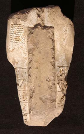
Small Finds
1. Ushabti made of high quality faience, with most of the glaze lost. Some faint traces of turquoise colour
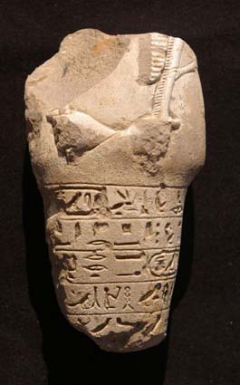
Above left and right : Ushabti, front and back.
Maximum height 9.8cm, maximum width 5.3cm, maximum thickness 3.2cm.
Below left and right : Ushabti side views.
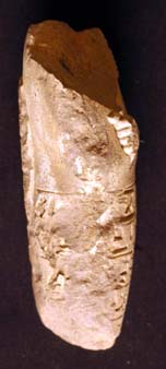
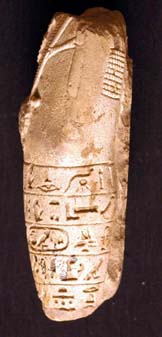
The ushabti has lost its head and feet, there is damage to it right side, the hands, upper body surface is lost and the back pillar is chipped. The condition is good, although some of the surface seems a little powdery. The remaining surface is now mostly white in colour, but the back pillar is brownish, suggesting that it may once have been a different colour. The figure is mummiform and wore a nemes tripartite wig-cover. He holds a hoe in his right hand and a basket in his left hand over his shoulder.
Parts of five lines of text are preserved on the body.
Transliteration
Translation
1. Illuminating the Osiris King of Upper and Lower Egypt Psamtek .. forever. O…
2. this ushabti, if this one….
3. King of Upper and Lower Egypt, Psamtek true of voice to perform (any) work
4. in the necropolis land, then you will remove any hindrance….
5. to the desert edges in…..
The ushabti figure is one of the royal ushabtis of a King Psamtek but it is not clear from this object which king it is. The quality of the material suggests that it could be Psamtek II Neferibre (595-589 BC), but the fact that there is no ‘Son of Re’ name suggests that it may be of Psamtek I Wahibre (664-610 BC), the first of the Psamtek kings. There is, therefore, only an outside chance that it is Psamtek III Ankhkare (525 BC).
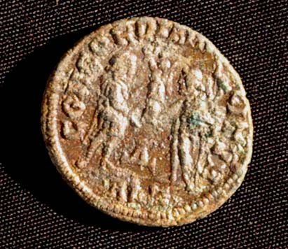
2. Coin of Emperor Maximianus
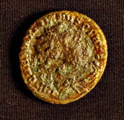
A small bronze coin, diameter 1.8 cm.
On the obverse (left) there is a head wearing a radiate crown.
The inscription begins:
IMP C MA MAXIMIANUS SP
On the reverse (below) a scene of a male figure presenting a globe with a winged figure to another figure on the left. The inscription above it begins ‘CONCORDIA’, between the two figures is a triangle on a stand, and underneath ALE.
The coin is a follis minted in Alexandria from the reign of the Tertrach Maximianus between 285 and 310 AD.
Both of these small finds were registered.
Other finds, which have not yet been studied fully, include :
i) A fragment of limestone with traces of a relief scene showing the head of a cow or bull wearing a tall feathered crown. It was extremely worn and broken.
ii) Around twenty metal copper alloy metal disks were found some of which may have once been coins but were so corroded that nothing was visible on the surface. Some of the disks seemed to have never been stamped suggesting that they could have been tokens or blanks.
iii) Fragments of small unguentaria (perfume) bottles.
iv) A headless figure of a nude woman reclining upon a couch.
v) Many small fragments of glass and faience.
vi) Fragment of a moulded pottery bowl with blackened rim and red body. The decorative scheme included a swastika design and floral patterns.
vii) Small fragments of Attic black glass vessels from oinochoe and lekythoi.
viii) Some copper alloy nails which probably came from the red brick building.
Summary
Excavation 10 discovered part of a substantial red-brick building with a curved feature inside it and an industrial zone
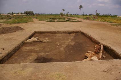
General view of the site towards the end of the season’s work.
outside the building suggesting a preliminary identification as a church with an apse. It may have a mud brick foundation inside it which itself seems to have been built upon an earlier mud brick structure. The pottery indications are that there are underlying Saite layers which have been disassembled to build later constructions. Some of them may have been built in the Ptolemaic period (from Ptolemaic pottery in the foundation trenches) into the early and Later Roman periods from the fourth to fifth centuries AD onwards.
A reinterpretation of the geophysical data suggests that the curved feature may continue to the edge of the ‘Great Pit’ and the straight wall of the building continues to the north-east in parallel with the mud brick wall inside it.
The two finds which were registered from the excavations represent two firm dates, but both are from disturbed fill [10.001]. The royal ushabti of a King Psamtek from the Dynasty 26 is from the early part of the chronological sequence and is most likely to be further beneath the excavated levels. The coin from the late third to fourth century represents a period of activity at Sais which is otherwise not well attested.
Both the Ptolemaic and Roman material fill in a useful and interesting gap in the chronological sequence so far obtained by the Durham University/EES project.
Conclusion
This season’s work represents a very interesting aspect of the archaeological history of Sais. The trench has been excavated to a depth of between 75-90 cm and the ground water is only at another 5 cm below this level, so it would not be desirable to dig down much further from the point of view of the building.
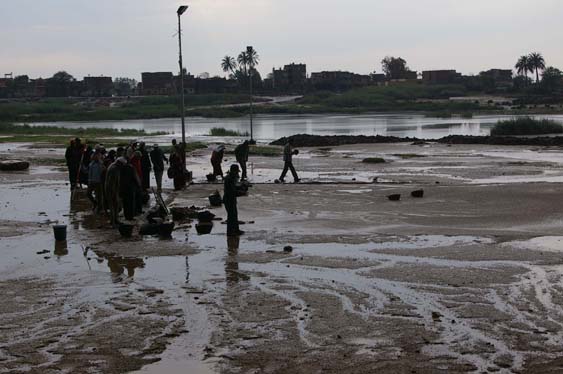
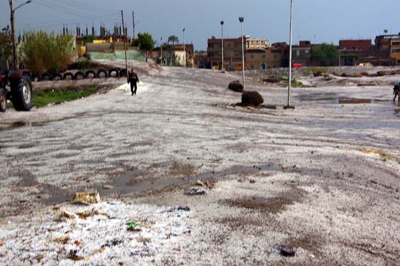
Above and below : Extreme weather conditions at Sa el Hagar.