Saïs Survey Report, 2000
Saïs Survey Report, 2000
SUMMARY
- Confirmation of the existence of several phases of large Saite buildings existing under the koms and hills of Kom Rebwa.
- Discovery of an area of late Predynastic-Early Dynastic settlement and of Buto-Maadi cultural material on the western side of the Great Pit, beginning at approximately 1.5-3m below the lowest modern ground level.
- Continuation of the drill core survey to give a good sample of cores around the site
- Completion of visual survey
- Trials of various sampling methods (field walking, test pits, sections)
The team at Sa el Hagar were in the field from 3rd August to 22nd September 2000 and consisted of: Dr Penny Wilson (Director, Durham University), Mr Gregory Gilbert (Archaeologist, Macquarie University, Sydney), Mr Daniel Lines (Drill Supervisor, Birmingham University), Ms Rachael Dann (Finds supervisor, Durham University), Ms Shakira Christodoulou (Drill Assistant, Cambridge University), Mr Ahmed Fouad Rashwan, Chief Inspector at Tanta (SCA Representative).
The team worked in three main areas and carried out six smaller projects.
Drill Cores
A new drill head set had been purchased for the use of the Sais expedition and we were kindly loaned the Saqqara team’s set for a month which meant that we could have two drill teams working at once. As a result we completed 38 cores this year to give a total with those of last season of 53 cores. We made horizontal transects across areas of the Northern Enclosure and Great Pit and in the farmed area between the Enclosure and Pit. We also made more random investigations in the village of Kawady and in specific areas of interest at the site including the western side of the Great Pit and the southern gateway of the Northern Enclosure.
Preliminary analysis of the results confirmed that the river was closer to the area of Sais/Sa el-Hagar than its present course, that there is gezira sand in a number of locations, that there is early pottery on the West side of the Great Pit, that Kawady village was indeed some kind of settlement in Roman times and may have been a small tell at one time, but is now totally gone, and there is a thick layer of charcoal and clay or peat about 7m below the bottom of the Great Pit lying over a wide area and possibly of the same date as some of the early pottery. The drill hit limestone and quartzite blocks in a number of places in the area of the southern gateway of the Enclosure and in the field where a magnetometer survey had shown up buildings about 3-4m below the surface in 1998.
Excavation 1: Kom Rebwa
A 10 x 10 metre trench was begun in Kom Rebwa in the eastern part of the area. The place was chosen because it was a rectangular series of hillocks with a flat depression in the centre and the trench was put across one of the ‘wall’ hills to examine the inside and outside of the area. It contained a substantial wall running almost exactly through the middle of it about 5m wide. The wall had been constructed of mud brick with layers of thick pottery between the courses and so the disintegration of the wall meant that the pottery in it was released. We sieved all top strata to get as much material as possible for a pottery typology. The material from here has been dated to the early Saite period (by Peter French who kindly looked at some sherds we took to Buto) and so the wall is either early Saite and contemporary with the pottery used to build it, or possibly later Saite using pottery which had come from earlier structures in this place. Also among the debris of the wall were 22 fragments of terracotta votive cobras, presumably either the goddess Wadjyet or Renenutet. There was no Roman or later material here as previously thought.
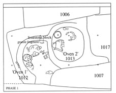
Phase 1 (above) and Phase 2 (right).
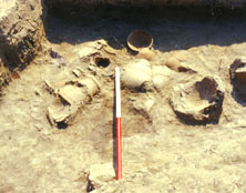
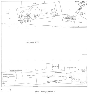
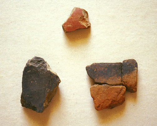
West of the wall: a series of ephemeral walls running at oblique angles to the main wall were uncovered. They seem to represent several phases of use and occupation on the outside of the wall and included two circular mud brick ‘cupboards’ or possibly ovens, which contained approximately 24 mostly complete but all fragmentary vessels including a carinated bowl, two pot stands, an amphora and bowls. There was also a small anteroom built up against the main wall with a curving wall going to the east and a large limestone pivot stone. This room produced much pottery and outside the door was a dump of organic material including chaff and manure and several more associated fragmentary vessels. This material may date to the Third Intermediate Period. There was also a rim fragment from a Dynasty 5 ‘Medum Bowl’ which may be the prototype or ancestor of the Dynasty 26 carinated types.
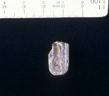
East of the wall: this area was filled with debris from the main wall and again included much pottery and also a small fragment of a limestone statuette whose exact nature is unclear and a fragment of a granite offering table. We reached a floor level perhaps associated with the destruction of earlier buildings here, complete with a muddy floor and limestone door pivot. Directly under this was a series of walls, with mud brick floor tiling running at an oblique angle to the main wall. This seemed to have been completely cleared down to the floor before the new massive wall was built. In the northern end of the trench there was further evidence of the destruction of the buildings here with some patches of burning. In this area were extremely small fragments of gold foil attached to wood or cartonnage, and also a few beads, part of a faience ring with a deity depicted on it (however its head was missing) and an interesting flint assemblage. The date of this clearance, however, depends on the accurate dating of the pottery.
The excavation confirmed that the hillocks in Kom Rebwa are not all just sherd piles, sieved out of the sebakh, but that some still contain structures and that it is possible to excavate here without problems with the water table. The Saite date of the pottery suggests too, that this area may well have been simply abandoned at the end of the Saite period and the city moved to the location of the modern village. There was a chance that there was a case of reverse stratigraphy here and that the sebakkhin had already dug out this area, so that the earliest material had been thrown out on top and we would then have come down to Late Dynastic, Ptolemaic, Roman and so on. This does not seem to be the case here.
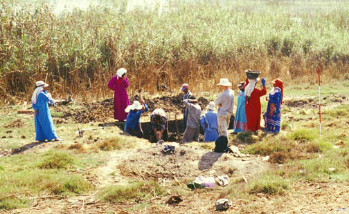
Excavation 2: Western edge of Great Pit (Birket Kebira)
The area was chosen because of the results of Drill Core 15 in 1999. It had collected possible early Predynastic pottery sherds at a depth of 7m and we wanted to assess the feasibilty of being able to dig down to this depth using a water pump to remove excess water. It was also an exercise in checking the core results against reality. We dug a 3m by 4m trench down to a depth of 3m with a step and sump at the southern end and removed water from the sump as necessary. At the depth of 3m we had already dug through 1m of sand which now formed the sides of the trench. This meant that they were unstable and with overnight water they were dangerously unstable. We therefore stopped the work on the grounds that it was too dangerous for the workmen to continue and were not prepared to start shoring up the sides of the trench because of the expense and time factor involved. The trench was then immediately backfilled.
However, we had gone through various archaeological strata: at the top there was some Ptolemaic and Roman pottery but this mainly came from the top disturbed rubbish layer. The pottery, bone and other material from between 1.5m and 3m down however dates to the late Predynastic and Early Dynastic period and it seems we had found the early material by accident (as so often happens). One sherd may be an Upper Egyptian imported ware.
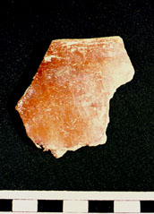
The dating was confirmed for us by Peter French and Ulrich Hartung at Buto and they suggested that the pottery from 7m may belong to the Buto-Maadi cultural phase dating to ca 3500 BC. It was interesting that the drill core had picked up the matrix of the PD pottery but not the material itself. It seems to be associated with an oven and burnt area and possibly is on the side of a river terrace or levée. In this case it is most likely a settlement area rather than a cemetery and is close to our suspected gezira. The depth between the two levels is perplexing with about 4 metres separating late PD and the Buto-Maadi-Sais phase and then with the Late Period pottery almost straight on top of it. The alternative is that if this is a river channel, the pottery may have been washed down the river and re-deposited here, so that it is not in situ. The most extreme result of this is that it does not originate from Sais. However, only future work will enable the stratigraphy and precise context to be made clear.
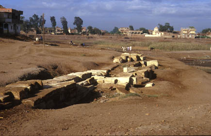
Combined with the drill core results from this area it seems the early part of the site so far runs along the western edge of the Great Pit and possibly under the houses to the west. There is also a temple foundation and a casemate foundation here, probably on top of the early material, so that it is possible this is indeed the oldest settled and perhaps ritual area of the site.
Other Projects
- Section through a rubbish dump at the west side of the Great Pit: contained pottery of the 8th-7th century BC including Greek imports, and also possible Ptolemaic material.
- Field walking in a field north-east of the SCA/Police office: yielded a range of material from Late Dynastic up to the modern era.
- Test pit 1m by 1m and to a depth of 30cm in a field to the north-east of the SCA/Police office (but different from the above): yielded a small amount of diagnostic pottery (not yet fully analysed).
- Section of sherd hill in Kom Rebwa east: the hill was sieved and all sherds counted. The diagnostic material served to build up a pottery typology for Sais and in fact was very similar in date (early Saite – Saite) to that from Excavation 1.
- Visual survey of Great Pit area especially on the western edge: to assess the results of test pit excavations carried out by the SCA on behalf of the Sa el Hagar council.
- Various surface finds from walking around the site including Greek black gloss ware, African Red Slip and East Greek pottery.
We also set up a collaborative project with Professor Mahmoud el Gamili of Mansoura University to drill six deep wells in the Sa el Hagar area. This should provide information on the local channels of the river and be invaluable for the analysis of our results at Sais itself. He is also looking at samples taken from the drill cores to analyse environmental data at Mansoura.