Saïs Report, 2005
Saïs Report, 2005
The mission worked at Saïs from 1st March until the 20th April and consisted of: Dr Penelope Wilson (Field Director), Angus Graham (UCL, Drill Supervisor), Dr Joanne Rowland (UCL, Finds Illustrator), Dr Gregory Gilbert (Durham University, Finds Specialist), Dr. Sally-Ann Ashton (University of Cambridge, Roman pottery), Karen Exell (Durham University, Drill supervisor and Finds Illustrator), William Cooney (Durham University, Archaeologist), Fatma Rageb Kamal (SCA Inspector). Valuable assistance was also given by inspectors at Sa el-Hagar: Mohammed Osman, Said Ibrahim el-Assal, Emad Mohamed El Shenawy, Ibrahim el Desouki, Mohammed Abd el Aziz and by inspectors in Beheira Province loaned by the Chief Inspector Fawzy Fawzy. Thanks are due to the Chief Inspector in Tanta Said Abdul Mutalib Kalifa as well as to the EES Representative in Cairo Dr Rawya Ismail; Dr Magdy Ghandour and his Office for the SCA in Cairo; Mr Hassan Barbary and Company for the the dewatering equipment; the police and gafirs in Bassioun and Sa el Hagar and Ashraf, Reda and Senne el Bishe for running the household and local liaison.
There were four main types of work in the season: a) Drill core Survey; b) Excavation in the Prehistoric Area in the Great Pit (Excavation 8); c) test excavation in Kom Rebwa (Excavation 9); and d) pottery and finds recording and especially from previous seasons.
DRILL CORE SURVEY
The drill core survey made fifty-three cores concentrated in three main areas of the Sa el Hagar region. In the earlier part of the season cores were made to the south of the village, near the mosque of Sheikh Abas. They showed the presence of an old river levee and confirmed the westward trend of the river over time. They also showed that settlement in antiquity was concentrated in an area south of Sa el Hagar and may be related to the favourable boat anchorages which could have been found in this area. The second area of coring was to the west of the Northern Enclosure area.
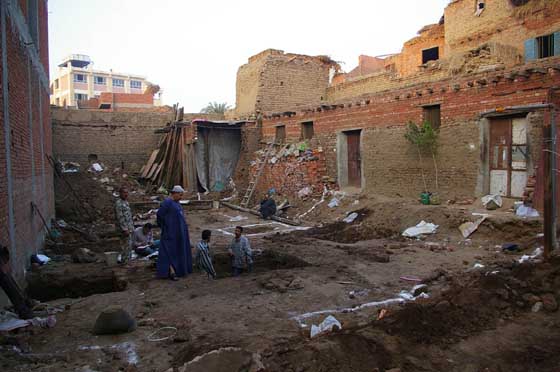
Drilling in the foundations of a house in Sa el-Hagar.
Satellite photographs of the area show an old water course here, very close to the eastern enclosure wall and the coring confirmed its presence by locating blue-black mud containing shell fragments at various places. The final area of augering was to the west of the Great Pit area. The work was carried out in order to delineate more finely the nature of the archaeological material between the Great Pit and the river levees to the west. It is possible that in the Saite refurbishment of the site material was removed and thrown out to the west in order to create a protective barrier as well as strengthen the riverside. The cores provided good evidence for Saite and other activity and reflect the spread of the site and its redevelopment at this time. A total of 217 cores have now been made at Sa el Hagar creating a good picture of the underlying topography of the area and archaeological zones.
EXCAVATION 8
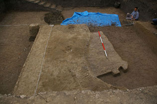
A 10m by 10m trench was excavated on the western side of the Great Pit to a maximum depth of around 3m. In order to be able to maintain the stability of the site and to keep the ground water away a dewatering system was successfully used. The area of work was selected following the earlier Excavations 2 and 3 and further refined by drill auguring in the area. This early work showed that there were Saite deposits overlying Prehistoric material and that there were several distinct layers of archaeological deposits. Though Excavation 3 showed the presence of both Buto-Maadi material (ca 3,800 BC) and late Neolithic material (ca 4,000 BC), the exact relationship between the various strata had not been clearly defined and the material sample size was small. In view of the pressure from building on the land in the Great Pit it was felt desirable to make a large scale excavation here. If the presence of the Neolithic material could be confirmed then it would be the first Neolithic site to be excavated in the flood plain of the Nile Delta or valley, with important implications for understanding the development of the delta in prehistory.
There were two distinct phases of material from Excavation 8 — an upper phase of Saite material and a lower phase of Prehistoric material.
The Saite Phase
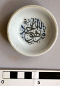 Modern dish. | 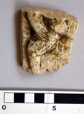 Limestone plaque showing Bes. | 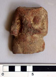 Terracotta female figure. |
The Saite material comprised large amounts of pottery and stone from a destroyed monumental building and possibly the foundations of that building. The destruction debris from the building contained a small amount of late Ptolemaic and early Roman pottery, suggesting that this may have been the date of the dismantlement of the buildings here. The Saite pottery is of the same type and date as the material found in Excavation 4. It comprised a large amount of Greek imported pottery including Clazomenian and Lesbian amphorae with some East Greek fine wares. There were also examples of the ‘torpedo’ or Phoenician amphorae from Syria and a large variety of red polished and coarse ware Nile silt pottery. It dates from the end of the Saite period, and possibly into the Persian period perhaps as a result of the refounding of some of the buildings at Sais after the Persian invasion in 525 BC. The Saite rubbish dumps had been disturbed in modern times as parts of the Saite zone had been moved over the top of the original tips as part of the modern refurbishment of the site.
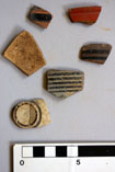 East Greek fine wares. | 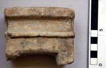 Limestone votive door fragment, similar to that found in spring 2003. |
The foundations of a monumental, perhaps temple building were also clear in the excavation. At some time in the Saite period, the area had been cleared down to the top of the gezira sand. In order to create the sand filled box with mud walls for the building, the Saite builders had dug down to the natural sand, levelled the sand hill and cut a large east-west oriented trench into the sand. The trenches were then filled with black clayey mud, perhaps dredged from the river, and this seems to have formed the foundation of the subsequent building which was then totally removed later. As a result of this construction technique the Saite levels came down directly onto Prehistroic material with no intermediate strata. The large mud filled trench contained a deep pit with Saite pottery near its base. This may have been a well at one time or perhaps for foundation deposits. A few pottery vessels recovered from the pit could have been interpreted as foundation offerings, but there was not the type of material which would usually be found in such a context. As a result, the pit seems to have been a well.
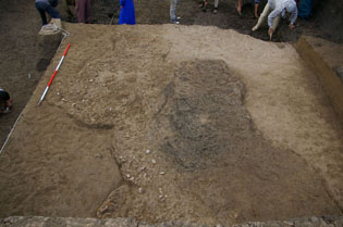
 | Saite period trench cut through sandy, prehistoric layers and filled with black mud. |
The Prehistoric Phases
There were three distinct phases of Prehistoric material with some intermediate layers.
I Buto-Maadi phase [8009]
This phase was identified by its pottery and lithics. It comprised an upper layer of pottery and flint debris which seems to have either been rubbish thrown back onto the settlement or layers of pottery from the sand had settled out leaving a concentration of pottery debris in concreted sand. Once this material was removed, there were some structural features which could be interpreted as a grey mud floor with post holes around it and pottery concentrated at the edges of the floor. This feature was mainly in the north and centre part of the site, as the relevant stratum had been cut away on the southern side by the Saite trench.
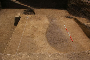
 | Grey mud platform to the right, with pottery and debris lying against it to the left. |
 | Earlier phase of excavation of platform and pottery dump. |
 | First phase of mudbrick platform showing post holes. |
The pottery from the rubbish dump included straw tempered and untempered wares, as well as southern Egyptian imports and some Palestinian wares. The main types were open and straight rimmed bowls, closed ovoid vessels and large bread trays. There was a good range of fine ware and some sherds decorated with impressed patterns. A large amount of pottery seems to have been polished but this had not survived very well and after washing the pottery was subject to further degradation through salt action. An estimated 12,000 sherds were recovered after total sherd recovery and seiving. The flint blades included some small trapezoidal arrow heads, as well as a large amount of chips and some cores. A few objects were also found including two beads, some ivory fragments and possibly parts of two miniature pottery nails. Below this level there was a layer of brown alluvial mud suggesting that the sand hill had been flooded prior to the settlement in the Buto-Maadi period. The preliminary date for this material is around 3800 BC.
 Pottery ‘nails.’ | 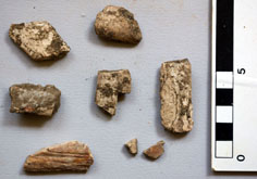 Fragments of ivory. |
 Body sherd of vessel with wavy handle (above) and decorated body sherd (right). | 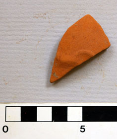 |
II Sais Middle-Late Neolithic [8013]
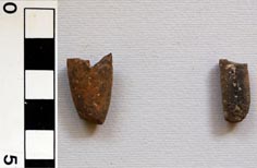
The whole area of the trench was carpetted with an average 3-4 cm layer of pottery, again the result of sand having been washed out of the original piles of pottery. Once the pottery was removed several features were apparent, probably from a settlement context. The pottery from this level showed a preponderance of untempered wares, with fewer straw tempered wares than in [8009]. There were also a larger number of sherds with impressed decoration than in the previous level. There were many highly polished bowls and open vessels, but a large variety of forms were recovered making the corpus an important assemblage of late Neolithic material. A good number of fired bricks were also found in the layer, probably from ovens or hearths. All sherds were kept and a preliminary estimate of the number suggests that around 50,000 sherds were obtained for future study. The layer was seived, so that small bones including fish bones were recovered for future study. Two beads and some possible bone tools were also found. There was also a number of bifacial flint tools including two hollow based arrow heads, a sickle blade, some sickle stones and a bifacial blade. They corresponded well to the late Neolitihic levels at Merimde. A number of stone grinders made from red or brown orthoquartzite were also found. A huge quantity of flint and stone chips were kept for future study as this seems to have been a major industry at this time.
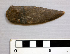
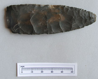
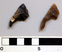 Concave-base, bifacial flint arrowheads. | 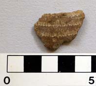 Body sherd with stamped decoration. |
 |  Pottery net-sinker or loom weight (left) and bifacial flint knife blade (above). |
With the removal of the pottery, some pits and post holes were apparent, though again their interpretation is difficult and the exact form of the buildings here is not known. A pit containing a large amount of charcoal could have been a fire pit or hearth [8023]. Nevertheless it seems likely that the area of the trench covered at least two if not three structures, perhaps part of one dwelling complex.
III Sais Early Neolithic [8032]
Between Stratum II and III there were other levels of settlement evidence:
[8030] This covered most of the eastern part of the trench and consisted of a level of red burnt material which left a series of patterns in the sand showing either pot emplacements or post holes and longer slots, perhaps for wooden beams. There were also some associated deeper pits filled with mud and pottery debris (though this may have come from the context [8013] above). Some reconstructable vessels came from this layer.
[8027] This covered the middle part of the trench and consisted of a patch of brown-black staining which may have represented a burnt area or hearth, though it could equally have been formed as a result of natural oxidation processes, perhaps from the decay of plant or other organic material (burial?).
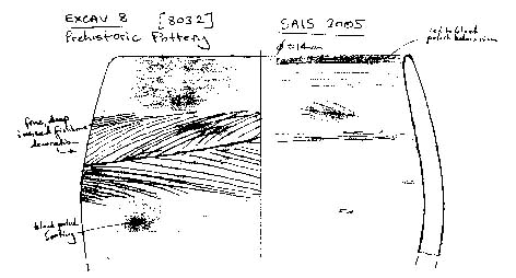
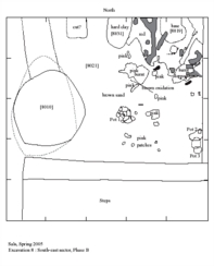 | Plan of South-East sector, Phase B. Click image to view at full-size (requires PDF Viewer browser plug-in). |
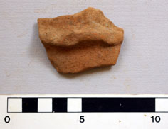
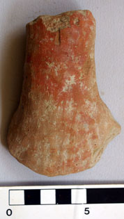 |  Pottery handle (left) and bifacial flint blade (above). |
[8021] was the sandy matrix between levels II and III and seems to have contained pottery similar to that from above, suggesting that pottery from above had moved through the sand layers. The sandy context had two main layers – a grey sand and a yellow sand. There were also some wind blown sand intercalations. The actual sand seems to be a from a river levee and has been reworked by river action and deposition as it is not like the coarse gezira sand noted at Buto.
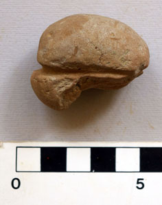
The third main level itself [8032] consisted of a thick (up to 10cm) layer of concentrated red and black burnt material which was mostly made up of fish bone and pottery, with a noticeable decrease in the amount of flint chips and tools. This level was also associated with an increase in sherds decorated with incised ‘herring bone’ pattern. As this layer seems to have been associated with fish processing on large scale the fish pattern on the pottery may indicate the primary activity and production concerns of the people living here. This level is clear in the western part of the trench where there was also a red burnt hearth and a cooking pot in situ. It dives down under the eastern section and could have been situated on a river bank. It may be in a protected position on the eastern side of a levee which would have been ideal for settlement.
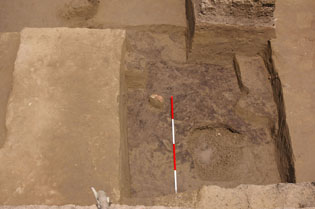
Black, burnt fishbone midden [8032]
In the fill above this level there was a bone harpoon blade. It has three barbs and a notched tang for fixing to a stick. The bone had been fire hardened and the object is in almost perfect condition.
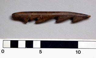 | Left : Bone harpoon in perfect condition. Below : Drawing of rim sherd of pottery vessel with incised herring-bone motif). (Drawing by Gregory Gilbert.) |
Further work below this level was not possible due to time constraints.
The results from this excavation demonstrate that the settlement in this area in Neolithic times was initially dependent upon the river with a community catching and processing fish on a large scale. The fish midden recovered at Level III may have been the result of one season’s work, rather than have been a permanent fixture. As such it could suggest seasonal settlement by people coming here at an opportune time of year. Level II and Level I by contrast reflect people accomplished in the manufacture of stone tools for hunting and fishing and the increased amounts of animal bone reflects the dependence on domesticated animals for meat, while the sickle blades show that agriculture was being practised by a more sedentary people. The increased amounts of straw tempered pottery as well as imports from Upper Egypt and Palestine also reflect the increasing economic and technological sophistication of the inhabitants of Sais into the Buto-Maadi period. Excavation 8 at its most basic reflects the model of development of communities from Neolithic seasonal hunters living off the land to settled farmers with domestic animals, to communities with further links and moving into the state formation phase of Egyptian life. The real difference is that this simple transition is all represented at Sais, rather than just one phase being present. It is most like Merimde Beni Salame, but further work will establish whether there are overwhelming similarities or clear regional differences.
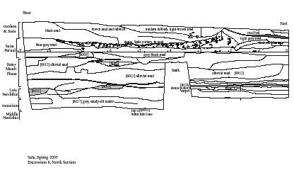 | Excavation 8, North Section. Click image to view at full-size (requires PDF Viewer browser plug-in). |
Most impressive from the material finds is the range and types of prehistoric vessels, as well as the pottery technology. The fact that prehistoric Egyptians had the ability to make fired bricks and yet never developed this technology is also an interesting observation. The presence of large amounts of orthoquartzite used for grinders and as an abrasive is also interesting as it suggests that the material was being especially brought in from the desert quarries. The material may have had other uses or significance and the large numbers of chips of the stone which have not otherwise been worked may suggest that the stone was used as a firestone and so its colour reflects its use to make fire. Sparks could have come from striking two such stones together.
The large amount of material recovered from the excavation requires further study, but raises some exciting prospects and questions about Egyptian delta prehistory and understanding the development of Egyptian settlement sites.
EXCAVATION 9 (original notes by William Cooney)
A further test trench (5m x 5m) was excavated in Kom Rebwa west immediately North-East from Excavation 6 (2004). The aim of the work was to obtain further information about the development of the Third Intermediate Period settlement in this area and to clarify the complicated stratigraphy of buildings, burials and domestic features.
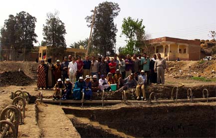
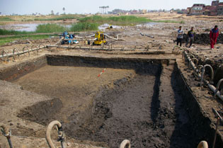
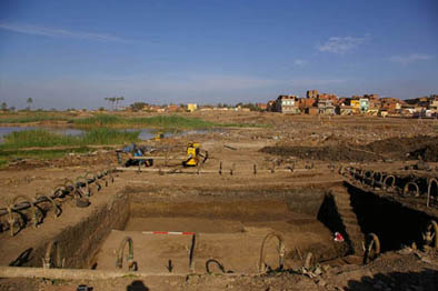
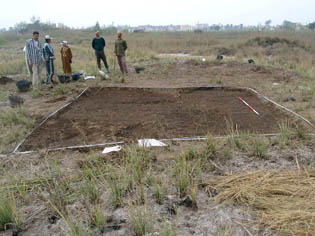 | Before work started on Excavation 9. |
The site consisted of two distinct phases with a settlement overlying an earlier burial layer.
The Settlement
The main feature was the corner of a mud-brick building in the south-western part of the trench, which was probably the north-east corner of the building from Excavation 6 (2004). There was also the last course of bricks of the walls of a building in the northern part of the trench. Both buildings are roughly contemporary and contained a large Nile silt ware rimless pot placed against one wall, which in both cases may represent a cooking area of the structure.
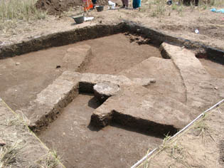 | Defining mudbrick walls with pottery jar emplacement. |
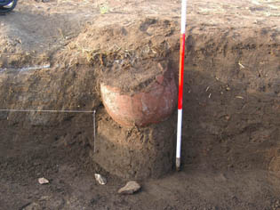 | The large pottery vessel against the wall. |
In the northern building, a large amount of ash, animal bones and pottery fill were associated with the cooking pot. In the southern building, the pot was also associated with ashy layers to the west which were visible in the section. A hearth was also located along the inside of this wall, extending into the western baulk. The fill between the structures contained fallen mud-brick and traces of mud-brick walls, suggesting that there were changes in the layouts of the buildings. Just below the surface, in the north-east corner, there was a large pottery dump [9002] with animal bones, probably dating to the Third Intermediate Period. A similar pottery dump was located, at a slightly lower level in the south-eastern corner [9018]. This pottery was of a similar date and was associated with a heavily fragmented disarticulated human skull.
The Burials
In addition to the human skull, four complete human burials were located within the trench. Two adult burials were located midway along the Eastern baulk. They appear to have been buried together in a mudbrick structure. One [9035] is lying flat with its head in the west (facing east) and lies underneath the second [9021] which is lying flat on its back, its head to the east facing north. The former is clearly sloping down from the head into the eastern baulk and its back is broken above the pelvis, so that the legs (only one femur of which is visible) extend into the baulk at an odd angle. This may have been done to accommodate the second burial which might also explain this body’s lack of a right arm apart from the proximal third of the humerus. The remaining left arm was placed in a flexed position, with the hand resting below the chin. No grave goods were associated with this first burial. The second burial was located above and to the south of the first burial. It was complete apart from the feet, both of which were missing. The full length of this skeleton from the crown to the fibula was 155cm. A beer jar, located next to the left knee, was the sole grave good associated with this burial and is of Third Intermediate period date.
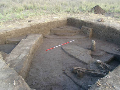 | Mudbrick houses built over earlier burials . |
Apart from the two adult burials, two child burials were also found in the northern part of the trench. The first [9037] was found in the north-east corner and was stratigraphically earlier than the two adults located to the south. The head was placed at the west and was probably facing north. The child was buried on its side in an apsidal mud structure (head in the apse), and appears to have been buried with an animal, the skull of which was placed around the right shoulder. A large animal bone and a pottery scatter were located in close proximity to the child and may represent grave goods, though their relationship to the mud structure was difficult to define. Some copper, however, was found between the apse and the North baulk, though whether this was associated with the burial or the hearth fill which surrounded it is difficult to determine.
The second child burial [9029] was located in the north-east corner of the trench, underlying the floor level of the northern building. The full length of the body was 48 cm, though its head was in the western baulk. There was no evidence of any structure around the body. The only grave goods which were visible were small (outer diameter 2mm) red, blue and white clay beads, which were located under the pelvis, along the right side. These may have been part of a bracelet on the right hand, or a belt along the pelvis.
A test section [9058] between the burials uncovered a large pottery dump, whose full extent could not be explored because of the overlying burials. It was clear, however, that it extended below both the child and the adult burials to a depth of 1.3m below the surface and made a mound feature under the two adult burials, who appear to have been placed directly on top of it. Due to the interference of the adult burials, it was difficult to trace the extent of this feature to the south of these burials.
Pottery and Finds
Most of the pottery throughout this trench dates to the Third Intermediate Period, possibly extending into the late New Kingdom. Many coarse Nile silt ware vessels were found on the site, particularly at the bottom of the deep trench, interspersed with finer Nile silt ware bowl rims and some closed jar rims as is expected from a domestic site. A common vessel appears to be a type of bread mould with a central distal hole, though many “ordinary” bread mould sections were also found. In total, thirty six flint bladelettes and cores were found and most of these were associated with hearth contexts. A small piece of ivory with regular external ridging was located under the Eastern wall of the Northern building. Additionally, a few small bits of copper and slag were found scattered throughout the site.
The evidence from this site suggests that the area had gone through successive phases of settlement, burial and settlement in the Third Intermediate Period, a tradition which is paralleled at many other sites throughout the Delta.
SUMMARY
The work was successful in its aims of studying the development of settlement at Sais during both the Prehistoric period and the Third Intermediate Period. A large amount of material was recovered for study in the future study seasons all of which will contribute directly to the research questions of the AHRC project. In addition to the exciting results of the archaeological excavation, the team continued to record material from previous work and work towards the publications of the project.