Saïs Report, 1999
Saïs Report, 1999
The season began on September 13th and lasted until October 6th 1999. The team members were Dr Penny Wilson (Director, Durham University), Mr Neal Spencer (Surveyor, University of Cambridge), Mr Daniel Lines (Drill Core Supervisor, University of Birmingham), Mr Martin Russell (Archaeologist, University of Liverpool), Mr Henry Fisher (Archaeologist, Durham University) and Mr Abdullah M. Abou el-Hassan (Inspector).
We are very grateful for all the help and kindness received from the SCA Inspectorate at Tanta and from the people and guards at Sa el Hagar itself.
Our work concentrated on two main areas of research and also included several other aspects.
Topographical Survey
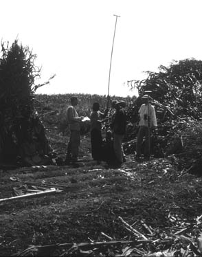
Though the 1997 season produced a map of the archaeological area at Sa el Hagar and Kom Rebwa, we also needed a map of the wider environs of Sais with details of the field usage in the area and local topography to provide the geographical context for the site. In addition, the village of Sa el Hagar itself had not been mapped adequately. In order to do this the team used a Trimble GPS 4800 Total Station which uses satellites to give precise longitude and latitude measurements and height. It is calibrated to a local grid to give measurements accurate to the centimetre. All team members under the supervision of Neal Spencer helped with the survey.
We mapped the extent of Sa el Hagar to the south and also discovered that the older part of the village stands on a small but noticeable tell 7-8 metres above the general ground level. The survey extended west to the River Nile and mapped an old flood embankment running along the inside length of the river bend, 3km to the north to the village of Kafr Daour, and to the east taking in the Qadaba Canal, main road and the village of Kawady.
Drill Core Programme
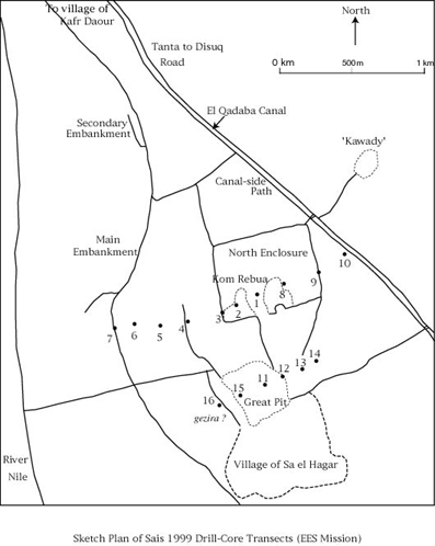
A series of 16 bore holes was sunk in two transects : (a) west to east from the River across the northern Enclosure to the Qadaba Canal, and (b) across the Great Pit area. Though the analysis of the core samples and cultural remains has not yet been made, the preliminary findings suggest that this method will be extremely successful in providing a ‘keyhole’ to the underlying archaeology at the site. The technique has, of course, been used elsewhere in Egypt with great success (for example at Buto, and the EES projects at Memphis and Helwan) but it seems ideal in the delta because of the difficult nature of excavation here.
At Sais it seems there are deep deposits of pottery and other cultural remains down to a depth of 5 metres from the current ground surface in the North Enclosure.
In addition, the cores suggested that there was indeed the last part of the east and west wall in the North Enclosure, further to the west there maybe traces of an extinct river channel closer to the Sa el Hagar than the river is now, and there may also be a buried sandy gezira running just to the west of the site.
These interesting results suggest that a future campaign with further drill core work will be just as successful and essentially amount to ‘pin-hole’ excavation of parts of the site and its environs.(1)
Saïs Drill Core Data
The ground level is taken to be at 5 metres above sea-level, from the contours of the 1:50,000 Survey of Egypt Map.
| Point Name | Latitude | Longitude | Ground Level | Depth of core |
| Survey Station | 30° 57.950 ‘ N | 030° 46.133 ‘ E | 5 m | |
| Core 1 | 30° 58.321 ‘ N | 030° 46.140 ‘ E | 5.75 m | 7.99 m |
| Core 2 | 30° 58.330 ‘ N | 030° 46.013 ‘ E | 5.18 m | 8.02 m |
| Core 3 | 30° 58.323 ‘ N | 030° 45.962 ‘ E | 6.39 m | 3.55 m |
| Core 4 | 30° 58.314 ‘ N | 030° 45.770 ‘ E | 6.25 m | 3.82 m |
| Core 5 | 30° 58.335 ‘ N | 030° 45.650 ‘ E | 6.32 m | 7.61 m |
| Core 6 | 30° 58.375 ‘ N | 030° 45.522 ‘ E | 6.00 m | 5.10 m |
| Core 7 | 30° 58.381 ‘ N | 030° 45.434 ‘ E | 5.27 m | 6.98 m |
| Core 8 | 30° 58.330 ‘ N | 030° 46.261 ‘ E | 5.18 m | 10.51 m |
| Core 9 | 30° 58.304 ‘ N | 030° 46.446 ‘ E | 5.93 m | 6.22 m |
| Core 10 | 30° 58.321 ‘ N | 030° 46.446 ‘ E | 5.93 m | 7.38 m |
| Core 11 | 30° 57.960 ‘ N | 030° 46.050 ‘ E | -1.36 m | 4.81 m |
| Core 12 | 30° 57.959 ‘ N | 030° 46.126 ‘ E | 1.24 m | 6.12 m |
| Core 13 | 30° 35.958 ‘ N | 030° 46.188 ‘ E | 4.87 m | 8.61 m |
| Core 14 | 30° 57.968 ‘ N | 030° 46.296 ‘ E | 5.25 m | 5.91 m |
| Core 15 | 30° 57.932 ‘ N | 030° 45.905 ‘ E | -0.41 m | 7.28 m |
| Core 16 | 30° 57.929 ‘ N | 030° 45.801 ‘ E | 5.78 m | 6.80 m |
Archaeological Investigations
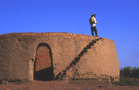
a) A series of small trenches was dug around the limestone wall planned last year. These indicated that this does seem to be the last few courses, perhaps even foundation courses of a monumental structure. The larger stones are sitting on smaller stone footings, on mud brick. The wall seems to continue slightly to the west, with further massive blocks being uncovered. In addition, the stairs were cleared down to a threshold but they were flooded by water, underlining the difficulties of excavation at the site.
b) A second limestone structure to the west was also cleared of rubbish in order that it could be planned and recorded. It too seems to be still buried under the surface soil and rubbish and its relationship with the main limestone wall is still unclear.
c) Two test trenches were dug on the east and west sides of the Enclosure Wall to the north, in order to establish if they were indeed mud brick under the disturbed surface. The results were unfortunately inconclusive, despite clearing down to a depth of about 1 metre and scraping and drying out the surfaces in the bottoms and sides of the trenches. The two trenches contained different contexts of mud and neither showed bonds or lines. Together with the drill core results, it seems that the west enclosure wall in particular is somewhat irregular at this point. It may be that the mud brick has been completely removed, or that the wall itself had a break exactly in the area in which we dug.
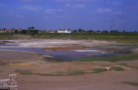
d) The surface material was scraped away from two small areas in Kom Rebwa to determine how much of the surface would need to be removed in the case of excavation. About 20 cm was removed to a harder surface and pottery and stone fragments from the surface layers were noted, though they were much degraded due to salt damage. The water table seemed to be relatively high at this point and though there was clearly some material which could be removed, not much depth could be achieved in the trench before it filled with water.
Recording
A new block, said to come from the village of Damat was copied and photographed. It shows the top of a Double Crown and is similar in size to the other quartzite blocks at the site.
Archive Work in Tanta
Work was begun in the SCA Offices in Tanta to examine the documentation and registers of the EAO/SCA as kept there. The documentation for Sa el Hagar has been put together in a huge library of folders and dates back to about 1960, though there are some older pre-Revolution documents. Every involvement of the EAO in the village is documented including their excavation reports for their work in the last 20 years. There is a fascinating wealth of material and we began listing the excavations carried out at Sa el Hagar and material found in the excavations as recorded in the Registers. This proved very useful in determining areas which have been excavated and the kinds of objects from the work. My work here was made possible by the good offices of the Chief Inspectors at Tanta and by the translating abilities of Ms Fatma Ragab Kamal.
Preliminary Results
The topographical survey and drill core results are beginning to suggest that the ancient topography of the area of Sais was different to that in modern times, as expected. Though there is clearly more work to be done to confirm our very tentative results, it seems that to the west of modern village of Sa el Hagar and just west of it there may be an ancient sand gezira, possibly the original settlement area. The river may well have been diverted to the west by this gezira, creating a kind of ‘shadow’ plain to the north. The western track of the river can be detected in our drill cores (5 and 7) and the ‘flood embankment’ to the west may well be a remnant of the river bank. It deserves some further study.
Over time the river has continued westward. Sais may then have been built on the gezira and the shadow plain. There always seems to have been a canal to the east and it may have been a weaker branch of the river, split by the gezira. In effect Sais could have been almost an island site, protected on all sides by the river and this suggests a strategic reason for the choice of the site. Other delta towns were built in similar conditions (such as Tell Balamun, Avaris/Piramesse) and it creates a picture in the delta of cities built almost as islands in the floodplain of the river. The changes in the course of the river due to excessive flooding or riverine erosion may then be determining factors in the history of the delta, affecting the fall and rise of its cities, such as Sais.
Notes
I am grateful to Professor Mahmoud el Gamili of the University of Mansoura and his team of soil scientists and geologists who enthusiastically gave us advice about the local river systems and interpretation of the soil samples.