Saïs Report, 2017
Saïs Report, 2017
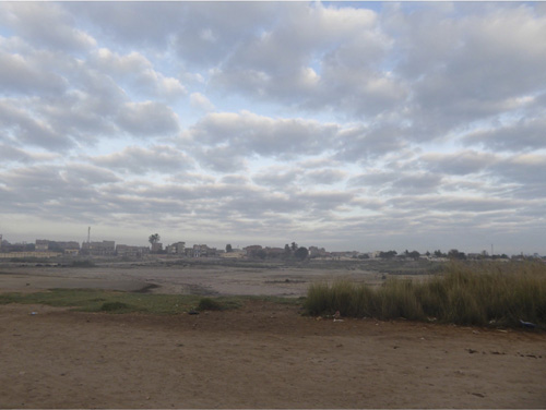
View towards the village of Sa el-Hagar
Introduction
In 2017 the Mission to Sais continued the work begun in 2012, focusing on the area in Kom Rebwa East containing material of a similar date to that in Excavation 1 (work from 2000-2005). We aimed to document as much of the excavated pottery as possible as well as continue to process material excavated in this season. We also wanted to carry out analysis of soil samples taken from the layers of earth excavated during the work in order to begin compile data on botanical and animal remains preserved in the soil. The aim was to find out what kind food had been processed and consumed at the site and perhaps also stored in the structures excavated at Sais.
In this season we took the opportunity to carry out further magnetic survey work in the agricultural fields at the site, as they were cleared during the harvest. The magnetic survey continued that begun in much earlier seasons (1999 and 2001). The aim is to build up a systematic and as complete as possible record of any archaeological traces buried under the agricultural lands.
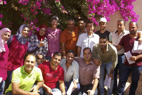
Members of the Sais Team in 2017.
The Team The Durham University/Egypt Exploration Society Mission to Sais consisted of: Penelope Wilson, Claire Malleson, Maria Cannata, Esmeralda Lundius, Kimberley Babicz, Madaleine Ager, Rannva Hoydal, Martha Rowe, Mark Learey, Nada Mohamed, Hoda Kamal, Mahmoud Emam, Mahmoud Arab, Rachel Frame, Mohamed Nasr (MoA Main Inspector), Walaa Reda El Nehrawy and Samar Ashraf Ramdan (MoA Junior Inspectors), archaeological trainees Khalid Mohamed Farouk, Mona Fouad Saad Eid, Essam Mohamed Kasim, Sobhy Salam Salam Hawis, El Sayed Farag Abd Elaal, Hamada Saied El Sayed, Mohamed El Refey Mohamed, conservator trainees Mohamed Abd-el Mageed El-Haggar, Mostafa Mostafa Haggag. I am grateful to Mohamed El-Sayed Sawaf, Mimi Ibrahim and Said el Asal at Sa el Hagar of the MoA for their help in facilitating the work, the police at Sa el Hagar and Bassioun for their kindness and interest in our mission and the el Bishe Household for their care. In Cairo we thank Mohamed Ismail, the Permanent Committee of the Ministry and Essam Nagy in the Egypt Exploration Society office.
Funding came from the Rust Family Foundation which supported the faunal work and training run by Claire Malleson, the magnetic survey and illustration work of Esme Lundius, Mahmoud Arab and Maria Cannata. We were also grateful to Durham University and the Department of Archaeology, North East Ancient Egypt Society, the University of the Third Age, Keith Raffin and Donald Wilson.
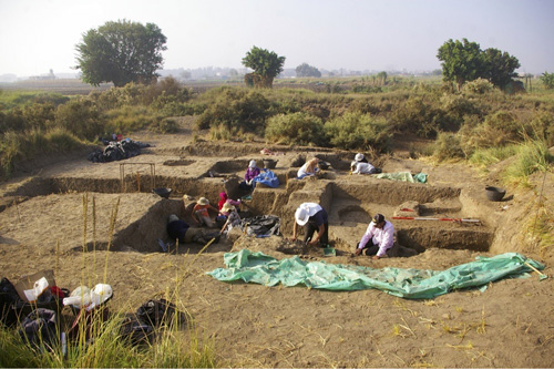
View over the excavation in 2017, towards the south-east.
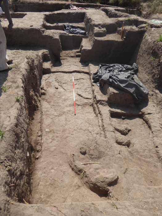
1. Excavation in Kom Rebwa
The excavation continued our work from the original excavation 1 in 2000-2005 and the continuation of the work from 2012 onwards. The overall aim of the work was to find the extent of the late Ramesside period ÅehouseÅf to the west of Ex 1, whether it has also suffered a collapse of the roof as in Ex 1 and, if so, the extent of that event further across the site. In 2017, the adjoining areas of Ex Units 12, 15, 21 and 17 were opened alongside Units 16 and a new area between Ex Unit 1 and 12 (hereafter 1/12) was cleared to understand the exact relationship between the previous excavation and the current areas.
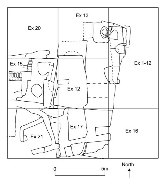
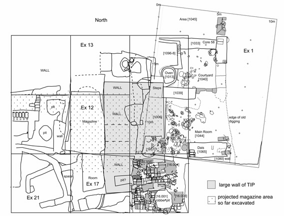
Plan of the Excavation Area in 2017.
A. Unit 12
Unit 12 contains the main magazine or storage and food processing area. The floor layers were systematically and slowly excavated in order to examine the different kinds of activity carried out in the magazine and, to some extent, to understand the length of time for which the magazine functioned. The magazine was half-sectioned by a line from north to south along the centre of the building. The eastern half was then sub-divided into two unequal sections by a natural fissure (crack) across it and excavation focussed on the southern part.
Unit 12 The storehouse viewed towards the end of the work from the north.
The floor layers were characterised by thin layers of white, orange, black-burnt or greenish soft material. In addition, there were patches of sand, especially where they had been used to support pottery vessels or perhaps dampen down fire-pits. The general matrix of the magazine varied between dark brown soft earth containing flecks of white, mineralised organics and black patches of charcoal with small rounded pottery fragments and harder sandy yellow or grey mud. Sometimes the matrices lifted off over more substantial white layers. They may have been caused by the deposition of decayed layers of matting or basketry, which had left the mineralised white layer on the floor. Mud patches, that did not contain any other material, may have been caused by water or liquids turning the soil matrices or mudbricks to liquid mud, which had flowed into hollows and uneven areas of the floor. Each individual micro-feature may represent one event or period of use for one day or over a longer period of time. It was not possible to record each one individually so the excavation chose to explore particular features, which had been preserved better. The features included the patches of white material described above, hollows filled with more substantial deposits of sand or other ashy material and some mud features. It seems possible that organic materials such as basketry or reed mats had once been placed on the floor surfaces and that they had been abandoned and then decayed leaving behind the white mineralised deposits.
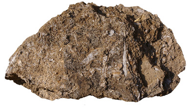
Detail of mineralised organic material from floor layers in Unit 12.
In addition, some structural features were also found including mud surrounds for pot-stands or mud-bases for ovens and bowl heaters. Sometimes mud-bricks were used either to support pottery vessels or for the people in the magazine to sit on. One of the main features exposed by excavation was a large amphora stand in the north part of the magazine. The stand may have functioned until the end of the magazine as the upper part of the pot-stand was prominent in the upper phases; there were signs of at least two other stands in the centre of the magazine and one ashy oven towards the southern end of the magazine. A stand in the southern portion had been built over a small oven-heating feature. The jar stand had been constructed by pouring a layer of mud into the last bowl in the fireplace/heating feature and then a further mud surround was built over the small heater.
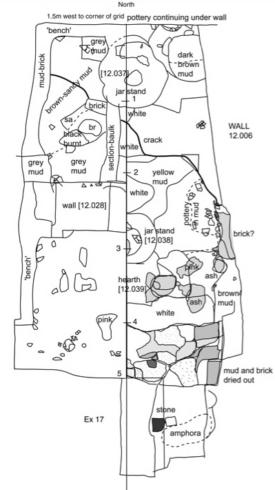
Plan of magazine and its features.
The magazine was most likely cleared or cleaned at intervals, by sweeping material to one side where it accumulated in piles against the walls to the west and north, or by burying rubbish in pits in the floor which were then covered over by matting, sand or more loose earth. Large amounts of broken pottery as well as a few more complete but smashed vessels were recovered from the magazine. As much as possible was collected in order to understand what were the most common types used every day. From the fragments of pottery, the most common types of vessel appeared to be small conical or round-base bowls, which were effectively disposable and once no longer needed when broken were thrown down onto the floor, perhaps to add some strength to the floor layers. The rims varied between extremely fine and thin-walled bowls, perhaps small drinking bowls to larger, more coarse and thicker walled bowls, perhaps for short-term storage, serving or heating food.
North-west corner of the magazine.
In the north-western sector of the magazine and the north part of the north-western sector of the magazine floor, the underlying matrices were more homogeneous, consisting of sandy-brown soil with few inclusions, quite solidly packed down against the bench or footings running around the magazine. It may be that there was a higher shelf or small platform at this end of the magazine.In the north-western sector of the magazine and the north part of the north-western sector of the magazine floor, the underlying matrices were more homogeneous, consisting of sandy-brown soil with few inclusions, quite solidly packed down against the bench or footings running around the magazine. It may be that there was a higher shelf or small platform at this end of the magazine.
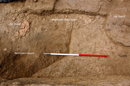
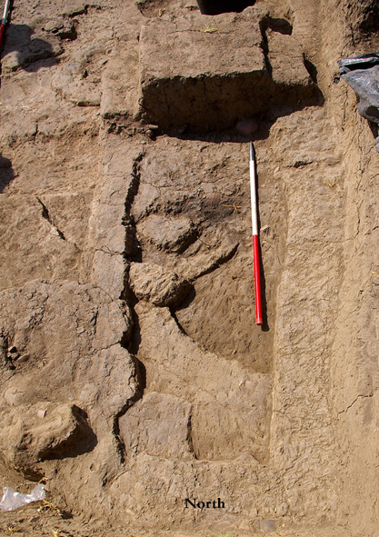
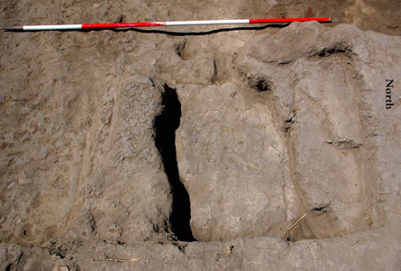
Fissure running across the unit 12 magazine.
A natural crack or fissure ran across the magazine floor in an east-west direction and the floor levels to the south of the crack seemed to have slipped downward and been displaced. This was evidenced by white layers on the floor apparently having been split in two and lying at a slightly lower level on the south side of the crack than the white floor layers on the northern side. The presence of the feature may support the idea of an earth tremor or subsidence that brought about the collapse of the magazine. More work is needed to understand the effects and evidence for earthquakes in alluvial environments, and to check whether there are any deeper sub-surface features Å\ such as structural voids or cavities Å\ that may have caused the collapse of the ground surface.
The wall detected across the centre of the magazine seemed to have been constructed over an earlier grey mud feature and pottery had accumulated against this wall. In the fill on the north side a scarab was found. It depicts the god Thoth and a cultic emblem or Maat-feather (SF 12.056).
The section of the floor layers showed the many micro-layers in the magazine but they are intact in the baulk through the middle of the magazine and also in the south-western sector which has not yet been excavated. In the future, samples of this floor will be analysed chemically in order to identify component elements of the layers and micromorphological analysis will also be carried out in order to study the deposition of the layers at very fine degree of resolution.
B. Unit 17
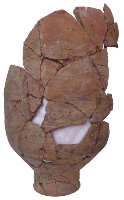
View of Unit 17 white layers.The area of Unit 17 lies to the south of the magazine and, potentially, the lower layers contain a continuation of the magazine or adjoining features southward. In the Upper City layers a series of small rooms were found including one square 1.5m by 1.5 m room with a white-washed floor. The pottery from the rooms was indicative of the date and joined some of the pottery sherds found here in previous years. Beneath this level the collapsed magazine layers were reached comprising dark brown mud fill, perhaps from collapsed mud brick, which had been partially flattened to create a relatively level layer for the building of the upper structures. Within the collapsed rubble there was found a large, four-handled amphora, which was flattened and broken, but complete so that it was possible to reconstruct the jar, thanks to the conservation tem. The type of amphora was already known from the magazine contents found in Excavation 1, but this example was very large with a height of ca. 83 cm, maximum diameter of ca. 43 cm, rim diameter 22 cm. Its position confirmed the last level of the magazine and also the fact that the magazine structure extended south of the doorway in Excavation 1, so that the length of the magazine complex may be as much as 10m from north to south.
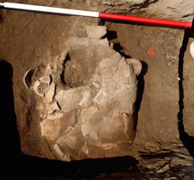
Amphora in situ.
C. Between Unit 12 and Excavation 1
An extension was excavated to the north-east of Unit 12 and east of Unit 13 in order to connect unit 12 with Excavation 1. The area between the two trenches was a triangle with its apex towards the north. In the upper levels of this area a large oven was found, inside which tree roots had grown and an amphora was found inside a niche or shelf within a wall. The access steps and sandy wall on the western side of Excavation 1 were found thus enabling the areas to be linked together and the magazine extent clarified. The oven and fragmentary amphora from this context could have been deposits dating to the Third Intermediate Period, but it cannot be excluded that they are also more modern and were left as a product of sebakhin digging.
The area between Unit 12 and Excavation 1 with ovens and amphora in the uppermost layers.
D. Unit 21
Work also continued in Unit 21 to the south-west of the magazine, where the floor levels of the domestic quarters were carefully removed. It had been assumed that the pile of pottery in the upper levels was connected either with the kiln production in the last phase of the Third Intermediate Period structure or with sebakhin digging. The layers of the room nearest the eastern wall seemed to be intact and ancient archaeological features, but the layers on the western side of the trench towards the south-west corner seemed to consist of mixed and loose rubbish-filled soil that included some residual material such as a cobra head, copper alloy rod or tool handle and a stud or gaming piece (see small finds description). The ‘rubble’ layer lying underneath the earlier pottery-filled dump seemed to confirm that the stratigraphy had been severely affected by the sebakhin digging but that the builders in ancient time may have used the earlier walls as a place in which to stay and cook. The layers at the base of the walls suggested that there were some additional structural features including a small line of mud-bricks at the wall base and extending out into the room. These structural features may belong to the underlying Lower City. The floor layers comprised ashy deposits, mud and some fill, along with pottery fragments of jars and bowls and some vessels, which had been left complete but were broken.
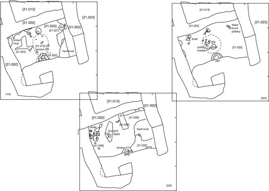
Plan of successive strata in Unit 21 in 2017.
Click image to view at full-size. (Requires PDF Viewer browser plug-in.)
2. Post-excavation work
A. The Pottery
A large amount of pottery sherd material kept in the storage magazine was studied. There was a total sherd collection policy for Units 12 and 21, so that material from different layers could be joined and compared if necessary. The sherds were sorted according to the colour and type of fabric, their surface treatment, thickness of ware and any identifying features such as wheel marks, specific fabric types or burnt examples. It was noted in Ex unit 12 that sherds from across contexts joined, meaning that some of the material has been disturbed and moved in the past and that the internal deposits of material from the upper levels in particular are quite mixed. This year we focussed on the reconstruction of several of the large amphorae, in order to have a clear idea about the storage vessels from the magazine.
Reconstructed amphora with ‘Tiger-stripe’ wash on exterior, height 50cm.
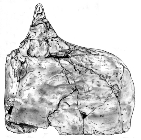
Those studied included: a red amphora with burning on the outside, a cylindrical amphora with an orange inside surface and cream outside surface, three ‘Tiger stripe’ jars, two jars with orange-cream slip on the outside, three small globular funnel-necked jars with burning on their bases, used for cooking, several small conical and round-based bowls, Levantine fabric vessels including Canaanite amphorae. Some of the small, more complete vessels were drawn as well as the ‘mousetrap’ vessel found last year.
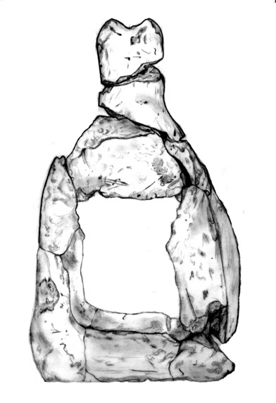
Left and below :
Drawings of the ‘rat-trap’, by Esme Lundius, showing the front (left) and the side (below).
The mass of body sherds and smaller fragments comprised many bowls of different sizes, ranging from fine cups, to medium sized bowls-lids and larger, thicker walled and heavy-based dishes as well as the internal-ridged bowls. A number of residual sherds were also noted amongst the pottery material including Medum bowl fragments and red polished wares (Old Kingdom), bread moulds (First Intermediate Period to New Kingdom), a polished, fine Prehistoric sherd and distinctive bowls with red painted rims, which may date to the early New Kingdom.
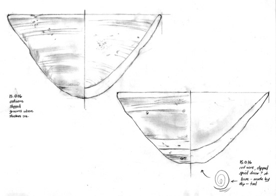
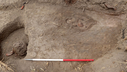
Conical bowls from Unit 15.
B. Faunal Analysis
Dr Claire Malleson oversaw the training of several team members in the process of flotation for the recovery of archaeobotanical materials. This involved taking samples of soil excavated from discrete archaeological features and mixing them with water. During the process the heavy sands and silts sink, the light botanical materials float on the water and are gathered in a specialized, scientific 300 micron mesh. The botanical materials are carefully dried and examined by the archaeobotanist under a binocular zoom-stereo microscope at 6-30 X magnification in the Sa el-Hagar Magazine work space. All of the heavier materials were also carefully washed and dried, and then sorted. They included: ceramic fragments, bones (often small fish bones), lithics and any other artefacts can be recovered for analysis by relevant specialists.
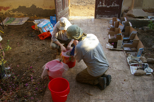
Flotation of environmental samples.
The samples processed and studied this season all came from excavations in the Third Intermediate Period buildings, and contained the expected assemblages of charred cereal crop processing by-products (cereal chaff, crop-weed seeds) from fireplaces and ovens in the settlement. A grape-pip was also found in one of the samples. As was the case with previous samples from this area of the site, the botanical materials have been badly damaged by the ubiquitous modern halfa grass roots, which infest the soil and cause damage to the fragile ancient plant remains. As the remains were in somewhat better condition than those examined previously, they promise more meaningful results when the study of the samples is completed at a future date. Samples from inside jars, from oven and hearths and from floor layers were also all processed. One of the jars from Ex Unit 22 found last year contained the bones of several mice that had lived in the jar at some time in the past.
When the material is analysed in future seasons, it is hoped that the species identified in the analysis can be linked to the pottery jars and vessels. The information will be invaluable for understanding the types of foodstuffs stored and processed in the magazine/kitchen area, the diet of the Ramesside and Third Intermediate Period towns and the lifestyle of the people who lived there.
C. Small Finds
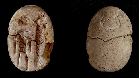
Scarab SF12.056 showing Thoth.
SF12.056 (Context [12.033]) Scarab, with image of god Thoth standing next to a hatched object, perhaps a Maat-feather or obelisk. Made from faience, but glaze lost. Originally in two halves, chip off base, now conserved. L. 1.65cm, W.1.1 cm, Th. 0.7 cm. The scarab may be comparable to an example found at Medinet Habu and dated to the twentieth or twenty-first dynasty (See E. Teeter, Scarabs, Scaraboids, Seals and Seal Impressions from Medinet Habu, Oriental Institute Publications 118, Chicago, Oriental Institute (2003): no 85, p.64 and pl.27a). The scarab here is described as having a falcon headed figure with sun disk and hatched maat-feather or obelisk. The beak of the figure is, however, elongated and so, like the Sais example is likely to be the ibis-headed Thoth with lunar disk and obelisk or maat-sign.
SF12.059 (Context [12.033] centre) made of Nile silt was a headdress from figure, with double plumes, sun disk and tang at the base. L. 6.8, W. 3.3,Th. 1.25 cm. One cobra head came from unit 21 (SF21.022), made from Nile silt also and from the area between the two main areas in the upper levels more cobra fragments came to light: (SF1/12.01 upper part of a cobra; SF1/12.02 a cobra body).
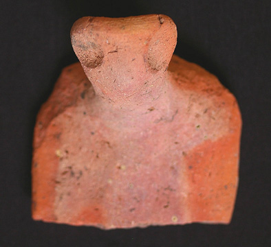
Upper body of cobra SF1/12.01.
A flint flake was found SF12.061 as well as a small flake or chip SF12.057, suggesting flint tools were used in the food processing, as well as a red-quartzite pounder or hammerstone, with two squared off sides and the remainder rounded (SF12.062). Elsewhere the flint tools are residual but common, again suggesting perhaps continued use and reuse (SF21.017), and a red quartzite flake (SF21.034) as well as stone pebbles which may have been used as grinders (SF17.029 and 17.030 may of chert, SF17.033 of quartzite).
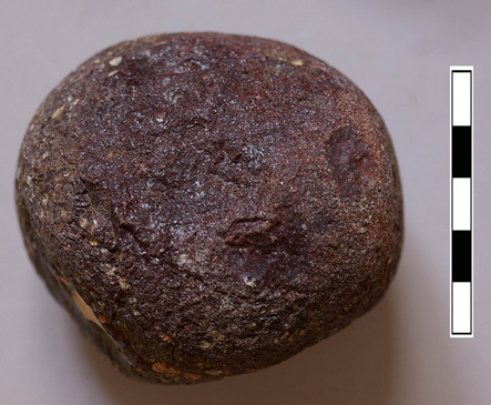
Red quartzite pounder SF12,062.
One ring bead (SF17.028) and a fragment of a spacer bead (SF12.058) was also found in the magazine, but they could be from much earlier periods, having been reused in the mud-bricks. Other personal decoration was found elsewhere including a hair-ring fragment (SF21.029 red glazed faience), a fragment of ostrich egg-shell perhaps intended for beads (SF17.035), a spherical bead made from carnelian (SF21.026). Objects of perhaps a more domestic nature were also found to add to those from previous seasons: a limestone pivot stone (SF17.032), a conical ‘gaming piece’ made of limestone (SF17.034), a pottery gaming piece or ‘button’ (SF21.030) and a spindle whorl or net weight made of pottery (SF15.100). Very little metal was found having mostly decayed, but a copper alloy rod fragment did survive (SF21.032) and a flat fragment (SF21.033).
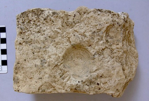
Pivot-stone, SF17.032.
The material is a useful addition to our previous small-find pieces, but the scarab is an interesting chronological marker —whether its context is residual or not — and even more interesting is that it provides a link between Sais and Thebes, suggesting some sort of connection or centre of production sending material out to the south and north.
3. The Magnetometer Survey
The survey work was undertaken by Mahmoud Ali Arab and his team in order to add to information previously obtained in 1999 and 2001. The equipment used for the survey was the Bartington Gradiometer dual sensor and we focussed on the available areas of the Great Pit and fields where the crops had been harvested, but before they were replanted and flooded. The results and information from the following areas showed some interesting anomalies:
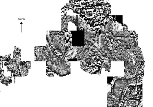
The Great Pit area showing differential magnetic resistance
A. The east side and northern edge of the Great Pit.
Previously the survey had collected small grids of survey data from the Pit including evidence for a 20m by 20m square building on the north-east kom of the Pit. The area was used as our test area so that the results could be compared in order to add to what had been found before. The survey made a complete map of the western and northern edges of the Great Pit with the building to the north-east showing up clearly, but there were some new smaller structures discovered near by as well as further large stone scattered around the area. On the east side of the Pit there were areas of intense magnetic anomalies, perhaps the result of the deep digging of ditches and pits that had then been filled in with material with different magnetic properties so that the ditches show up more clearly on the image; in the wide grey mud area, there were also some signs of relatively intense magnetic features underneath this area which was not been visible in the earlier survey work. Along the edge of the Pit between the areas of digging’ there were also visible some paler grey features, some with rectangular shapes and some with circular shapes which may represent structural features still extant in the Pit and showing that not everything had been completely destroyed. This means that some areas of the Pit would be worth further archaeological investigation.
B. Two areas of fields near Kawady village to the north-east of Sa el Hagar (2017.13).
One of the areas surveyed was known to be the place where excavations were carried out in 1961, 1965-6 by Fathy Malek and Ibrahim Amer Abu Youssef. In this area it was clear that there were some low-magnetism anomalies dispersed in the area of a large square structure and with some smaller features around it. This could indeed be the cemetery area with some coffins, perhaps made of limestone within a building or series of small structures. The lower levels of the cemetery seem to be present and this finding will be included in the forthcoming publication of the Saite Period.
C. Fields were surveyed in the area north of the kom of Sidi Shaheen farm (2017.11).
Previous work had detected some deeply disturbed ditches, but the area nearest to the kom seem to have some rectangular features buried under the field.
D. Fields between the two low koms of Kom Rebwa (2017.1).
The magnetic map shows a series of rectangular and square building, the largest 15m by 10m in a roughly east to west alignment running across the field. The surface pottery in the field dates to Dynasty 26, but these features may relate to the earlier phases of the site and date to either the late New Kingdom or to the TIP period.
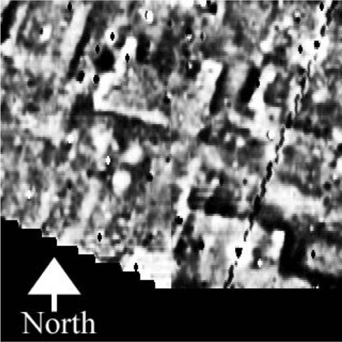
Fields to the north of Sa el-Hagar, magnetic map.
E. Other Areas
Further fields were surveyed as they became available after harvest of crops and showed either evidence for modern drains and ditches and more deeply buried earlier features. Of particular note were areas on the western side of the Enclosure (2017.4 and 5), in the south-western corner of the enclosure (with possible stone blocks indicated 2017.6) and on the south-eastern side of the enclosure area, where there was evidence for ditch-digging as well as some smaller rectangular or square features (2017.10).
The training of other surveyors also continued so that the work at Sa el Hagar can continue when there is available land for survey. The information obtained will enable a full systematic survey of the whole of the area at Sa el Hagar to be completed and the extent of the archaeological zones to be understood fully for the first time.
Summary
The work in 2017 aimed to discover the extent of the magazine from excavation units 1 and 12 and to understand why it had apparently collapsed after a time when it had been fully functional. The finding of a crack underneath the magazine gave some weight to the idea that an event such as an earthquake had caused the collapse, rather than a heavy rain storm for example, but it was clear that the later construction of the wall and smaller units against it had used many of the earlier walls, making the definition of the earlier structure difficult.
The relationship of the Upper Third Intermediate Period city and the late Ramesside city is interesting as the two cities are very different types: the Lower City is a large food processing and storage structure, of at least 7m by 7m, perhaps associated more with a an administrative residence or even temple than a domestic house; while the Upper City with its thick and monumental mud brick walls seems to be more compact and defensive changing its internal purpose from living quarters to more industrial activities.
Combined map of the earlier Excavation 1 (Phase III) and Units 12-15-17-21 from the second stage of work in Kom Rebwa.
The edge of Excavation 1 (from work in 2000 to 2005) was also identified in order to connect the old and new excavations. This enabled the size and scale of both the large wall (12.006) and the magazine to be investigated. In the area, the wall had a width of at least 5m (grey area in Figure 9), suggesting a substantial structure, but there may have been a corner and wall return in the area of Ex unit 13, so that the wall did not continue to the north. To the south a mass of brickwork suggests that the wall may have continued, taking advantage of walls beneath it from earlier phases to give it strong foundation and solid base. The magazine from the entrance in Ex 1 to the western wall in Ex 12, extending both north and now south for an unknown distance, was at least 8m wide and more than 7m long (dotted area in Figure). If the additional magazine in Unit 15 is also taken into account the magazine area of the settlement is considerable. Some of the rubble from the collapse suggests that the magazine may have had a vaulted roof. The magazine may then be part of not just a domestic house, but perhaps part of an administrative complex of some kind with large storage and food processing space. It could be related to the local governor or even a temple complex somewhere in the vicinity, and future work may uncover the exact character and relations of this building.
Although the progress with the pottery study, its reconstruction and conservation is slow, the basis and methodology for a future more concentrated season of work has been established in conjunction with the excellent conservation facilities provided by the Ministry of Antiquities. The results of this work combined with the analysis of seeds and plants as well as the analysis of the bones at the site, should enable a full picture of the foodways, lifestyles and health of the population in the two different time periods to emerge.
The magnetometer survey has also shown, unexpectedly, that under some of the fields there are clear structures, which may also relate to the earlier settlements at the site and may be worth more detailed investigation in the future as well as working towards the completion of a systematic map of sub-surface evaluation. We hope one day that the whole of the area at Sa el Hagar will be completely surveyed in order to understand the nature of the sub-surface archaeology and the zones of the ancient site.
View of the work at the site.
Saïs Report for 2017 in Arabic (Acrobat Reader 6.0 or later required)