Kafr El-Sheikh
Kafr El-Sheikh
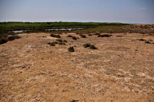
Kafr el Sheikh is the name of the northern central Province of Egypt which borders the Mediterranean. The northern part comprises Lake Burullus, a shallow freshwater lake with small islands and reed beds. Its southern edge was formerly marshy and swampy but much land was reclaimed here in Roman times and from the nineteenth century. Many fish farms have been developed here. The north of the area comprises Egypt’s main defence against rising sea-levels as it is only 1m above sea level. The agricultural land has the main town of Kafr el Sheikh an important agricultural centre, Simbellawein, Fuwa, Disuq and Mehallat el-Kubra.
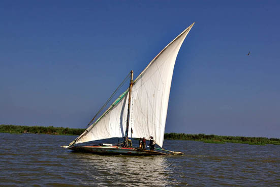
Sailing boat on Lake Burullus.
Tell Mutubis (Tell el-Ahmar) (SCA 090175) (Map number 52)
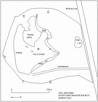
Plan of Tell Mutubis.
Click image to view at full-size (requires PDF Viewer browser plug-in).
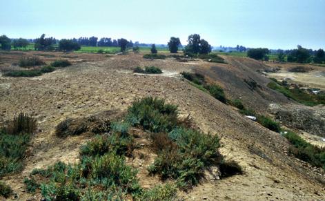
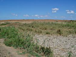
The site consists of a tell situated on the northern side of a flat area of about 650 metres by 550 metres in size. The tell is roughly rectangular in shape and has two long sides of approximately 280 metres and two shorter sides of about 180m forming a squat four-sided hill. It is 12 metres high at its highest point from the local ground level with very steep sides on the west and south and sloping sides on the north and east. This may be a result of wind erosion, digging or due to the type of structures buried under the mound on each of these sides. The surface of the tell has a red colour caused by the broken pottery lying on the surface. Where it is not red it is grey because of mud brick. There are also glass fragments, corroded coins, some stone fragments (including limestone, red granite and volcanic tufa) and organic material, particularly bones lying upon the surface.
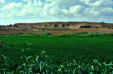
The main mound of Tell Mutubis from the south.
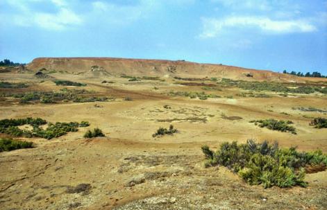
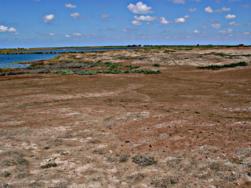
Tell Mutubis from the north, with flatter area in the foreground.
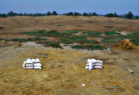
The western side of the mound has traces of mud brick walls visible along the edge, almost for the whole length of this side. At the southern end there are the remains of two parts of a red brick structure. One is still part of the mound, but the other seems to have been dug out in the past and is a water tank made of red brick and pink mortar. The tank (3.5 by 3.5 m), has a plastered inside surface and is almost full with rubble. Near these structures is a fallen fragment of floor with rough marble tesserae. The flat area to the west shows signs that it has been dug out leaving a number of depressions which fill with water in the winter. There is evidence for much red brick debris in this area, but it is not clear if it is in situ or redeposited here from elsewhere on the site. A number of tracks cross this area on raised causeways or embankments. One of them may be an old Light Railway embankment, leaving the main railway line at the south of the site.
Water tank left after sebakhin digging.
The southern side of the tell is also very steep, with some mud brick structures standing out clearly. Along this side there are other isolated mud brick features at the foot of the main mound, two noticeable fragments of red granite — one probably part of a column, the other with a clearly worked face, a group of limestone blocks which seem to have been recently dug out of the mound and further to the south there is a red brick building of some kind. A low mound also runs along the southern area of the site which may form a separate series of structures, along with traces of red brick walls in the ground.
A group of limestone blocks at the base of the mound on the south side.
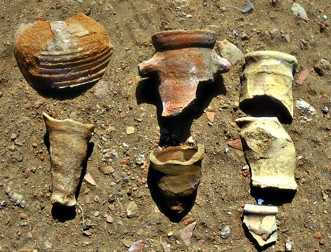
The pottery studied at the site included some ribbed Nile silt dishes and jars, fragments of African Red Slip ware dishes and plates including some with embossed decoration, amphora spikes and necks, some fine wares and a few marl vessel fragments. The material can be given a preliminary date of around the 4th-7th century AD.
Four drill core holes were made at the site and they suggested that the site has been occupied continuously from perhaps late Ptolemaic times to Late Antique times, maybe from the 1st century BC to around the 9th century AD. Much of this city was founded on clean alluvium (flood deposited sediment) and also perhaps on drained marsh areas. On the eastern side of the tell, there was, however, a possibility that there was some even earlier settlement and that the Roman town had grown from it.
It was difficult to discern from this initial survey whether the site of Mutubis could be identified with the major ancient site of Metelis. It was clear however that, although the surviving mound is a small part of the original site due to the activities of sebakhin, there is a still a substantial remaining part of a Ptolemaic and Roman town mound surviving.
Tell Qabrit (SCA 090167) (Map number 53)
Bibliography: A.J. Spencer in The Intellectual Heritage of Egypt, Studia Aegyptica 14, Budapest, 1992: 535-6.
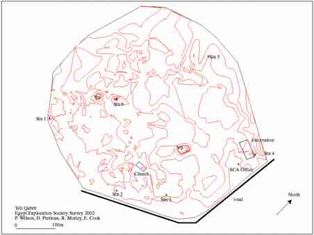
Plan of Tell Qabrit
Click image to view at full-size (requires PDF Viewer browser plug-in).
This small tell is situated to the north-west of Tell Farain (Buto) and to the east of the small village of Qabrit. There is no concentrated modern settlement around the site, but it is bordered on the south by a main road and on the other sides by fields. Some of the border areas are more like wasteland and may have been unsuccessfully reclaimed from the tell.
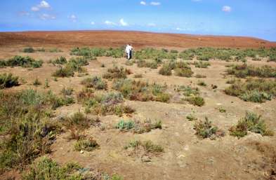
The tell has no cover except for small patches of brush and the soil is either red coloured or in places grey. There is a reasonable amount of degraded pottery, glass and red brick on the surface, but the tell is not densely covered. The dry surface dust forms a covering of about 20 cm and can be scraped away to the damper, more compact soil. In the early morning (and possibly after rain) building patterns can be seen on the surface, mostly occurring in the form of small squarish structures.
View of Tell Qabrit.
The tell is 4.1 m above the ground level at the site. It is 875 m from east to west and 757 m from north to south. The eastern to southern sides of the tell are relatively level on top running down to the edges in a gentle slope. The northern and west sides of Tell Qabrit are more uneven and undulate in a series of small hillocks and mounds. A few of the mounds towards the centre of the site form the highest points of the tell . The shape of the tell may be due, in part, to wind erosion with the wind blowing from north to south creating the smoother southern tail-back of the tell. It was difficult to discern any pattern to the hills, though some of the modern tracks may indicate more substantial walls beneath the surface.
Some excavations have been carried out at the site by the SCA including a series of Late Antique buildings to the south (2000) and a red brick church building in the central area (2001).
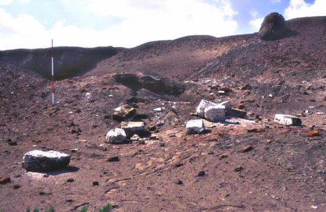
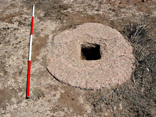
Seven large granite grinding stones are visible on the surface, probably having been uncovered during the sebakh -digging and left as they were too heavy to easily take away. One limestone block was also noted.
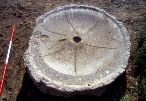
Granite grinding stone.
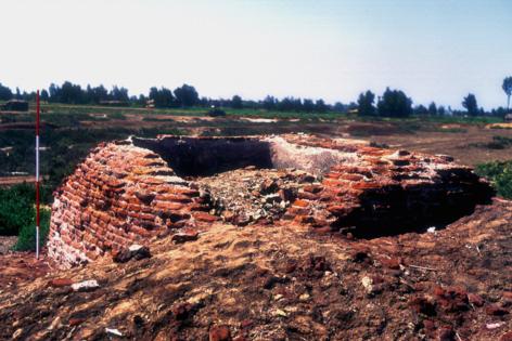
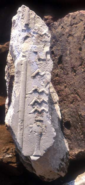
The church building was associated with pottery of the 4th-7th centuries AD. The surviving walls measure 26.5 m from east to west and 12.1 m from north to south and were about 1.05 m thick. They are preserved to a height of 65 cm. The church is made from at least two types of different sized red brick and had a rectangular outline oriented east-west. There is a remaining marble faced and lined font in the centre, but the apse has been completely robbed out. The building had limestone paving at the west end and possibly marble paving at the east end, though this had been removed. The walls of the church were originally plastered and founded upon layers of crushed limestone chips and earlier pottery. Among the debris a block with a few hieroglyphs in raised relief was found, suggesting that a Pharaonic site nearby may have provided much of the stone building material, or indeed, that there was a Pharaonic part of this site.
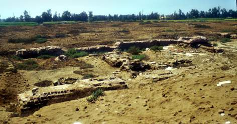
Above : Church at Tell Qabrit.
Left : Fragment of hieroglyphic block from the church at Tell Qabrit.
Tell Amya (SCA 090130) (Map number 54)
Bibliography: A.J. Spencer in The Intellectual Heritage of Egypt , Studia Aegyptica 14, Budapest, 1992: 535-9.
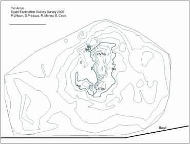
Plan of Tell Amya.
Click image to view at full-size (requires PDF Viewer browser plug-in).
This tell is smaller than Tell Qabrit, being 460 metres by 320 metres in size and reaching a height of around 8 m above the surrounding ground surface. There is a central high ridge, running from north to south, which seems to have been created by sebakhin diggers. The site seems to have been cleared away by sebakhin working from the east and west towards the central area.
The archaeological strata of the site have been extensively disturbed and it is difficult to detect any building features in the surviving areas. The amounts of red brick at Amya, the patches of grey mud brick and the pottery strata suggest that something once stood here, but its nature can not be determined by surface survey alone.
The ridge of Tell Amya.
The flatter areas and mound of Tell Amya.
The pottery from the site is similar to that at Tell Qabrit, with similar ARS/ Egyptian imitation wares, pottery with cream and brown paint stylised plant decoration, imported amphora, ‘carrot’ amphora, and a number of Nile silt ware bowls or basins with either ribbing or pie crust rims.
Amphorae at Tell Amya.
There is also a good quantity of glass at the site, but, in contrast to Qabrit there is not the same amount of slag-like brick work, that is, bricks which have virtually vitrified and smaller pieces of slag. A number of corroded bronze coins were found on the surface, varying in their state of preservation and ranging from about 0.5 cm in diameter to 2 cm. One large fragment of red granite had been uncovered by the sebakh diggers. It seems to be an unfinished grindstone, still with roughly cut surfaces.
Tell Amya is one of a series of Late Antique sites in this area forming an east-west line, perhaps running along the delta east-west road listed in the Antonine Itinerary.
Tell Matiur (SCA 090139) (Map number 55)
Bibliography: P. Ballet and T. Von der Way, ‘Exploration archéologique de Bouto et de sa région (époques romaine et byzantine)’, MDAIK 49 (1993): 9-12.
This site was also visited as it formed the most westward of the chain of sites along the Roman road. From the surface pottery, this site was of tenth century AD date. It is about 300 m across at the maximum and rises to about 6-8 m above the local ground level. A number of circular brick granaries or storage chambers have been excavated here by the SCA.
View across the antiquities area at Tell Matiur.
Kom Abu Ismail (SCA 090168) (Map number 56)
Bibliography: P. Ballet and T.von der Way, ‘Exploration archéologique de Bouto et de sa région (époques romaine et byzantine)’, MDAIK 49 (1993), 12-13 site 3, Kom el-Sheikh Ismaïl.
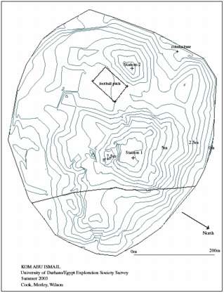
Plan of Kom Abu Ismail.
Click image to view at full-size (requires PDF Viewer browser plug-in).
Kom Abu Ismail covers a large area and is 631.4 m from north to south and 569.46 m from east to west, covering an area of around 36 hectares. It rises to a maximum elevation of 8.5 m above the surrounding fields. Pottery, glass and brick fragments cover the surface of the mound, giving it a reddish appearance in places. The tell stands on a small platform above the modern level of the fields and there are two main mounds, with a flat area between them. A track runs north-south over the site, perhaps upon harder underlying material.
View across the top and sides of Kom Abu Ismail.
At the eastern side, the ditch at the edge of the site had recently been cleaned out and a quantity of well preserved pottery was found here. The pottery from the surface was much affected by salt erosion on its under sides. One fragment of granite was noted on the main mound and a column base was found at the north-western edge of the site, measuring about 2 metres by 2 metres in size. It has a square base, with a graduated circle in the centre and is half buried in the ground.
Granite column base.A preliminary study of the pottery collected at the site suggests that two main groups of material were gathered. On group could be dated to the 3rd-7th century AD and the other to the 9th to 10th century AD. This agreed broadly with the dates of the pottery obtained by the Buto Regional Survey (4th-8th century AD).
Kom el-Misk (SCA 090138) (Map number 57)
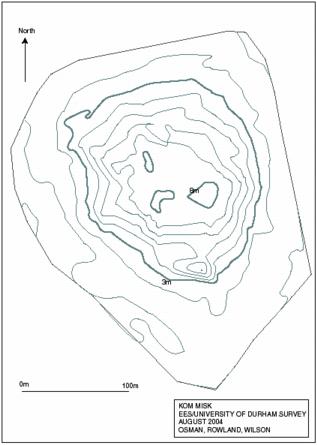
Plan of Kom Misk.
Click image to view at full-size (requires PDF Viewer browser plug-in).
Kom Misk is a small mound with a modern cemetery upon it, with the maximum dimensions 347 metres from north to south and 270 metres from east to west, rising to a height of around 8 metres above the level of the surrounding fields. The surface is loose powdery dark brown earth, with some pottery and red brick lying on it, most likely having come from some of the older tombs in the cemetery. There is a large tomb on the summit of the mound which was built in 1960 for Ibrahim el-Sawy. The outlying area of the site is flat and a track runs around it. This flatter area itself is about one metre above the level of the fields surrounding the site. The fields were checked for pottery but as very little was found, it is likely that the original site did not extend very far in this direction.
The low mound of Kom el-Misk with the larger tomb of Ibrahim el-Sawy to the right.
The pottery from the site reflects the more modern usage of the site. The earliest can be dated to the 4th century AD but, the most common date range is between the 8th and 10th century AD, into the medieval period. The types of material collected included strainers from water jar necks and ribbed amphora in light cream coloured wares. There were also some glass fragments lying upon the surface of the site.
Kom el-Misk is one of a group of sites with Kom Sidi Selim and Kom Bunduq in this area and it is likely that a defunct river channel once flowed from the south to Lake Burullus.
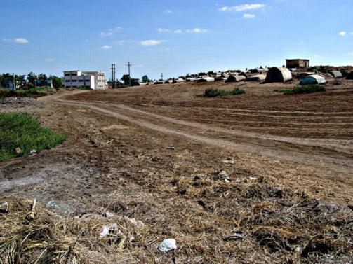
Tell Aluwe (Tell el-Farr) (SCA 090156) (Map number 58)
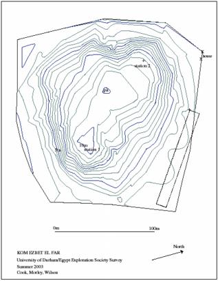
Plan of Kom Ezbet el Farr.
Click image to view at full-size (requires PDF Viewer browser plug-in).
The tell has a small flat edge and then steep sides rising to a plateau on the top. It has the maximum dimensions of 192 metres from north to south and 189 metres from east to west, rising to a maximum height of around 8.5 metres above the level of the fields. The sides are quite regular and at the time of the survey there was a recently dug 3 metre deep pit on the top of the tell. The sides showed several different layers containing pottery, brickwork and smashed limestone.
The site is probably the central remnant of a once larger tell, and seems to form part of the chain with Kom Dahab to the south. They may have been more of such settlements linked in earlier times. The surface had a covering of pottery and glass with some burnt, red brick fragments and it was clear from the pit that these strata continued down through the tell, which probably contains substantial remains of buildings.
The pottery from the surface was very degraded because of salt, and the dating of the material to between the 5th and 9th century AD suggests that there may be earlier material deeper under the tell. The types of pottery found included a casserole dish rim with pie-crust rim, some red slipped wares and an amphora spike made from a yellow coloured ware, with small limestone, grey and red particles.
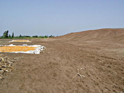
The steep sides of Tell Aluwe with corn drying on the flat outer area.
Kom Dahab II (SCA 090170) (Map number 59)
There was nothing at this site which suggested that it had been an ancient site. The area with this name is now a village and a cemetery, with the dimensions 131 metres from north to south and 77 metres from east to west. It had virtually no elevation above the surrounding fields, although to the north there was a depression, filled with water.
Kom Dahab (Hill of gold) may be a ‘joke’ name and show that the names of places can be misleading. It does form the southernmost point of the large ridge on the old maps with Kom Ezbet el-Farr (Tell el-Aluwe) to the north.
Cemetery at Kom Dahab II.
Kom Sheikh Ibrahim (SCA 090125) (Map number 60)
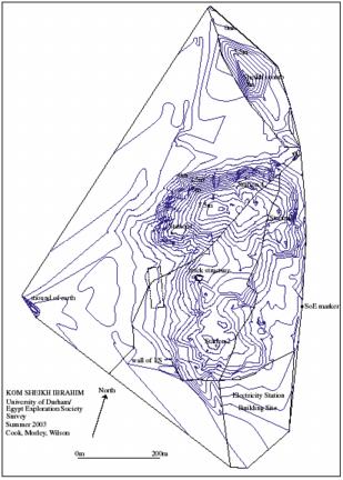
Plan of Kom Sheikh Ibrahim.
Click image to view at full-size (requires PDF Viewer browser plug-in).
The tell is a large mound 660 metres from north to south and 521 metres from east to west, thus covers an area of around 47 hectares. It reaches a maximum height of around 10.4 metres above the surrounding fields.
The site is a long, narrow mound from north to south, but may have up to two satellite areas on the west and east sides. To the north is the main mound area and a second mound lies to the south. Between them run two modern trackways making use of the firmer ground underneath this area and maybe reflecting underlying structural remains. The edges of the tell are flat, but raised on a platform about 1 metre above the surrounding fields. The surfaces of both mounds have a thin covering of pottery, glass and red brick. The southern mound has an exposed area of red brick building on its northern side, but it is not possible to make out any real ground plan and it does not seem to have been systematically excavated. The top of the mound, has traces of red brick buildings at the surface.
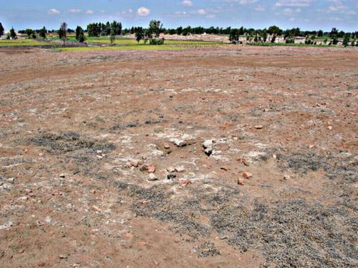
View from the top of Kom Sheikh Ibrahim showing red brick on the surface, with the modern cemetery mound to the east.
An area to the south has been sold to build a solar-powered Electricity Station and this was excavated by the SCA before the current builders moved in. The foundation trench for the wall surrounding the Station provided some good examples of pottery and at the entrance to the site, some stratigraphy with red brick buildings was visible.
There are two possible satellite sites. To the west is a small mound of earth, about 5-6 metres high. It did not have much pottery on the surface and seemed to be more a remnant of an earlier tell or field clearance.
To the east is the cemetery of the nearby village which is situated on a small mound, roughly parallel to the earth mound on the west. It was not possible to determine if either site had archaeological material in it.
The topography of the tell and its elongated nature suggests that either it was once a much larger site as a whole, perhaps up to and including the satellite areas, or that it enjoyed a long existence and spread in one direction or the other over time.
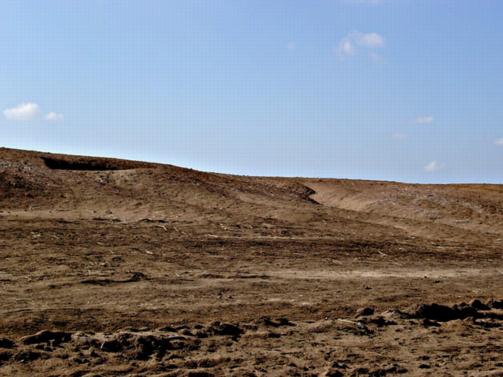
Side of the tell showing a rain-water gully.
The pottery could be mostly dated to within the range of the Middle to Late Roman period, concentrated on the 4th to 8th century AD. The types of sherds studied included a neck with a strainer from water jar, painted with cream paint, a Africana Type II amphora import, a number of pie-crust and ridged rim sherds, showing variable types, but all from large cooking vessels or casserole dishes, a body sherd from a Gaza amphora, with black resin coating on inside, a small knob from the base of a qadus (saqiya pot) and a fragment of a yellow glazed ware. There were also fragments of glass vessels on the surface, one of which was fused from exposure to heat.
Tell Foqaa (SCA 090107) (Map number 61)
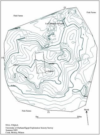
Plan of Tell Foqaa.
Click image to view at full-size (requires PDF Viewer browser plug-in).
The site is a large sprawling tell, with soft dirt on the top surface in most areas and some firmer sections, particularly the central tell area. The maximum dimensions of the site are 472 metres from north to south, 458 metres from east to west and the tell has a maximum height of 7.5 metres above the level of the surrounding fish farms. It covers an area of some 17 hectares, although the remaining site is most likely to be a smaller remnant of a much larger archaeological area. The sides have been cut back by the neighbouring fish farms. The sides of the tell are gently sloping, with a low ridge on the eastern side enclosing a lower flatter area of land.
Two fragments of granite grinding stones were noted lying on the site.
Granite grinding stone.
To the north there is a series of low mounds which may have been redeposited by excavation of the fish lakes or may represent archaeological remains. There is no asphalt road to the site and it is very difficult to reach. It forms one of a series of tells along the southern edge of Lake Burullus, including Kom el-Ahmar and Tell Retaba to the east. Kom el-Ahmar can be seen from Foqaa and Retaba from Ahmar.
Kom Ahmar (The Red Mound) with its distinctive colour caused by broken red-brick and pottery.
Pottery from the surface of Tell Foqaa was in bad condition due to the salty conditions. On the southern side there seemed to be proportionally more glass on the surface. The date ranges of the pottery suggest that this site existed from the Late Roman to the Islamic Period. The types of material studied at the site included a sherd of a large bowl with pre-crust rim and olive green coloured slip on surface, an amphora or jar base with button on outside, a body sherd, painted in purple paint on a buff/light orange background paint with a stylised eye and two fragments of bowls with dark green and opaque yellow glaze perhaps dating to the range of the 9th-15th century AD. Amongst the glass fragments there were some fragments of a glass beaker or lamp with blue egg-shaped decoration (cf. similar finds from Karanis, late 3rd-5th AD and Kellia 390-450 AD, after Bailey in CCE 4, 81-82). Three corroded bronze coins were also noted on the tell’s surface and one had traces of Arabic writing upon it.
Kom el-Akhdar, (SCA 090108) (Map number 62
This is a large tell in Lake Burullus, marked on the Survey of Egypt maps as Gezira Kom el-Akhdar. The tell has a narrow rectangular shape and a number of small inlets and harbours which allow boats to come through the reeds and moor. Our mooring point was formed by a number of large limestone blocks, possibly forming a low wall. The surface of the tell is sandy and in places covered with low growing shrubs, but it rises to a series of connected low mounds in the centre. There seem to be sandy-mud brick walls from buildings at the tops of these mounds.
The sandy surface of Kom el-Akhdar.
There is degraded pottery lying on the surface and buried in the sand and in the mud brick areas. Among the pot sherds were amphora body sherds, including imported orange wares with cream/olive slip and a few red slipped and polished finer wares. There were also glass fragments and some fragments of burnt brick. Though the tell is an island it is used to pasture cattle and also a small onion-like plant is grown there and collected for medicinal purposes. Some small-scale digging takes place and a large circular storage bin of pottery had been uncovered and smashed up. The surface material was not dense and the meagre remains extended mainly over the high parts of the island as far as could be judged.
Sidi Selim, (SCA 090153) (Map number 63)
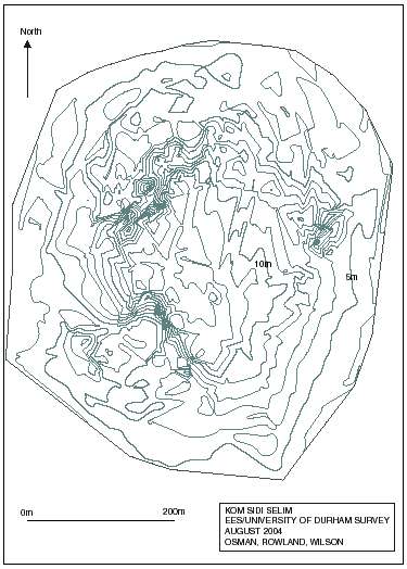
Plan of Sidi Selim.
Click image to view at full-size (requires PDF Viewer browser plug-in).
The site is a compact tell, though there is evidence of recent earth moving by bulldozer at the eastern side and a series of apartment buildings are under construction on this side. The mound extends 608 metres from north to south and 528 metres from east to west, rising to a maximum elevation of 13 metres above the fields around it. The top of the mound is quite flat and slopes away gently on the north-eastern and eastern side, but has steeper cut away sides on the south and west. On the north, there is a deep pit area, now used as a small football pitch and there is a granite block at the northern side of the area which is an eroded column capital, presumably a reuse. There are another two grinding stones of granite and a limestone block on the south-western side of the mound.
Sidi Selim seen from the western side, showing the height of the mound.
All of the sides are cut by rain water gullies, which have exposed new pottery. The excavation of soil on the eastern side has a section about 2 m high with pottery and red brick. The top surface of the mound shows some house plans which are more obvious with rainfall.
Pottery from the surface of the site and a trench dug for the foundations of new buildings on the western side of the mound area.
The tomb of Sidi Selim stands in a flat, low area apart from the mound, rather than being built upon it as is more usual.
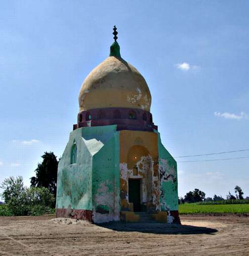
The tomb of Sidi Selim.
Kom Khawalid, (SCA 090122) (Map number 64)
The site covers an enormous extent with two main high mound areas and an outlying smaller hill. It extends 924 metres from north to south and 732 metres east to west, rising to a maximum elevation of around 15 metres above the level of the fields. The southern mound has a gently sloping top and then drops quite steeply down to the edge of the site. The other sides on the east of both main mounds are cut by rain gullies, some of them quite deep. The northern side of the site has some deeper dug-out holes, perhaps from illicit digging. The mound consists of soft brown earth underfoot with some more compact areas, particularly on the top of the northern hill, where a track runs over the mound. There is quite dense surface coverage of pottery and red brick and some slag in places. No real features can be seen, but geophysical survey work here could show the subsurface structures clearly. Medium sized chunks of limestone were noted in the bottom of the rain gullies. On the south-eastern side there is a canal which had been dredged recently and produced some large pieces of interesting pottery. Fields on this side of the site seemed to contain pottery also, so it is likely that the site extends further still. Building plans are visible on all the flat surfaces of the site, especially on the southern side and also on the eastern side of the northern mound.
The pottery on the surface of the mound seems to be of Roman to 10th century AD date and the sherds noted included strainers from water jar necks, pottery painted in orange, brown and cream colours upon a cream background, water-wheel pot bases, black amphora sherds. There were also fragments of glass, corroded coins and burnt brick upon the surface. The site is now being investigated by a team from the University of Uppsala.
The southern mound at Kom Khawaild, with survey team vehicle.
Kom Khanziri, (SCA 090121) (Map number 65)
Kom Khanziri is a large site, 500 by 500 metres and up to 12 metres in height, divided in two with a cemetery on one side and an abandoned military base on the other. Aside from this the tell is relatively untouched and there are good portions of it which could be explored further. The surface was covered in pottery and red brick. The site was identified as ancient Pachnemounis by Hogarth (Journal of Hellenic Studies 24 (1904), 1-19). The pottery reflects the dating of the site into the medieval period after the 10th century AD and well after the Arab conquest of Egypt.
View over the top of Kom Khanziri showing red brick debris covering the surface.
Kom el-Arab, (SCA 090172) (Map number 66)
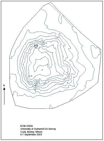
Plan of Kom el Arab.
Click image to view at full-size (requires PDF Viewer browser plug-in).
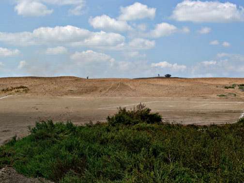
The kom measures 556 metres from north to south, 545 metres from east to west and is around 10 metres above the field level. The site has flat outer areas with a steep mound in the middle and a flat plateau on top. There are at least four granite grindstones exposed on the surface of the site. The surface is covered in pottery, broken red brick and glass. The slope on the southern side of the site is less steep than the north, probably due to wind erosion. A number of deep water gullies run down the sides of the tell. There is a football pitch on a flatter area to the south and on the south-western side at the side of the site there is a low platform of greyer mud. This may be a more modern threshing area, built up with mud, but it may also represent an earlier feature at the site.
Pottery, including rim sherds was collected from the surface and particularly from pits dug in the tell. The material can be dated between 4th-9th century AD, throughout the Late Antique period and it included the base of siltware bowl stamped with a circle containing stylised cross made up of small squares and a body sherd with painted decoration in white, red and purple.
Kom Arab, showing the flat outer area with mound rising in the centre.