Damanhur
Damanhur
The modern town of Damanhur is believed to have been the capital of the 15th nome of Lower Egypt, called Hermopolis Parva in antiquity. Although the modern name seems to have direct etymology as ‘demi-en-Hor’, the town of Horus, very little evidence of a more ancient settlement has been found here. The city itself has not yet been surveyed, however, and could, like Benha, conceal the traces of ancient remains under the modern buildings. It now contains governmental buildings because Damanhur is the capital of modern Beheira province.
Kom ed-Dahab II (SCA 100157) (Map number 40)
This is a low, flat area, partly covered in reeds and scrub and without significant features. The maximum dimensions of the site are 640 m from north to south and 220 m east to west. The area to the north-east is now occupied by a waste-materials processing plant of recent date. Small mounds of earth and rubble from its construction have been pushed immediately behind it to the south. A few red granite grinding stones and a limestone block have been gathered in front of the factory, again having been moved from the area cleared during the construction. There is also a football pitch covering part of the site. The surface soil of the flat areas is brown in colour and salty, with very little pottery lying upon it, although a few pieces were recovered for identification. If there was a tell here it has been almost entirely dug away to its base.
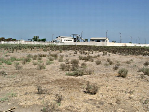
Flat area of Kom ed-Dahab beside the processing plant.
Tell el-Barnugi (SCA 100127 and 100128) (Map number 41)
Ancient Nitria, modern Barnugi, was famous in antiquity as the place from which natron was excavated and gave access into the Wadi Natrun on the western side of the Delta. It was also well known in the Christian period as a monastery site. It is most likely that it has an early history but work at the site would have to be particularly sensitive.
The SCA lists both Tell el-Barnugi North (El-Bahari) and South (El-Qebli). The local gafirs said that there was nothing left of Tell el-Barnugi North, so the survey visit concentrated on the other half of the site to the south. This site was extensive covering an area of approximately 560 m from east-west and 250 m from north to south. The area was roughly divided into two by a modern canal cut through the site and running north-south. The underlying surface matrix was very sandy, but there was more soil in small hills and mounds covered in sharp grass and camel thorn.
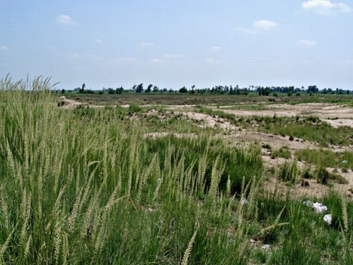
Sandy area of Tell el-Barnugi, with hillocks to the left.
At the eastern side of the site there was a football pitch beside the road and leading to the sandiest part of the site. In this sector, there was also a small mound of approximately 4 m in height, with the tomb of Sidi Sadallah el-Ansari upon it. At the southern end of the hilly area there was a large limestone block, other fragments of limestone and pottery sherds.
In the western sector, a series of small hills had been created by random digging and there were some quite large excavated areas. This area abutted fields and the village on the northern side. There was a black granite block in this area, close to the track running through it.
It is likely that the ancient site continued to the north under the village and thus formed some sort of larger series of towns with Tell el-Barnugi north. The dimensions listed here are for the extant area, although there is no real tell and the highest mounds here are no more than 1.5 m above the general ground level. It has been well denuded by sebakhin-digging.
There are undoubtedly archaeological remains in both parts of the site and under the cemetery mounds as it resembles both the sandy sites like Kom el-Hisn and the grass-covered mound sites, such as Kom Rebwa at Sais.
Kom en-Nawwam (SCA 100169) (Map number 49)
This site is located next to the Ezbet Kom en-Nawwam which contains the tomb of Sheikh Hassan Nawwam. The area covered by the site, but not including the villages on the east and west, is 280 m from north to south and 200 m east to west. It has no elevation, and lies slightly below the ground level of the village. The cemetery does, however, stand upon small mound about 2 m at maximum height.
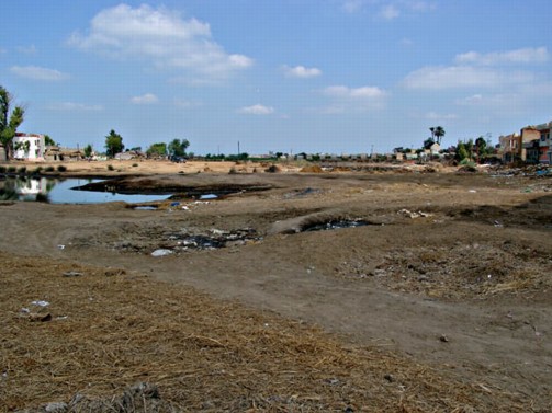
Kom en-Nawwam with the cemetery in the distance to the right and the flat area of the kom in the centre between two sides of the village.
The central area of the site is a flat, dark brown, dusty area, now used as a football pitch, although there are at least three large boulders of granite lying half buried in the area. On the eastern side of this area there was a marshy lake, which must represent a dug-out area filled with rain water and perhaps ground water. The village lies directly to the east of this pool. A small excavated area on the west side of the pool contained a mixture of pottery, broken limestone and burnt (vitrified) red bricks, perhaps from the destruction of the site.
On the western side of the flat area there was another set of houses adjoining it. Within this part of the village there was a red-brick and mortar construction being used as a duck coop. It was not possible to determine the age of this building. Local villagers suggested that it had once been a milling house. To the south of the flat area and in a small strip to the north between the football pitch and the road, the SCA had carried out some excavation work.
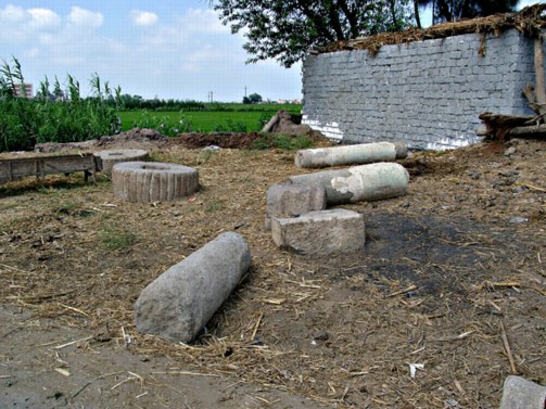
Granite blocks and columns at Kom en-Nawwam.
On the north-eastern side of the site there is the cemetery mound. A granite block formed part of the doorway of one of the tombs and there was a number of granite grinding stones, column fragments and other limestone fragments collected together at one side of the site. These may have come from the earlier buildings at the site or been brought here from elsewhere.
The pottery studied at the site could be dated to two main phases. There was a group from the Ptolemaic to early Roman (1st century AD) period and a second concentration from the 6th to 8th century AD.
Tell el-Shoqa (SCA 100112) (Map number 50)
This site consisted of a small mound with a cemetery on its summit. No measurements were taken.