Saïs Report, 2007
Saïs Report, 2007
Survey work
Storms clouds in Beheira.
The Naukratis-Sais link
As part of the wider regional study, some geological work was undertaken in Beheira province in order to locate possible river connections between Sais and Naukratis. Hosni Ghazala, Hany Shabaan and Adam Shehat of Mansoura University undertook this work on behalf of the Sais Project. As the Canopic Branch has now silted up, it has always been difficult to imagine how the Greek emporium at Naukratis could function as an ‘internal harbour’ for Sais in the same way that Peru-Nefer played this role for Memphis, because there was no obvious linking canal or waterway. The geological work was undertaken between Kom el Geif in Beheira Province and Sa el Hagar in order to build up a geological map of the area and to see if it was possible for a channel of some kind to have connected Naukratis and Sais, that is to have run from the Canopic Branch to the Rosetta Branch. A series of deep drill augers and Vertical Electrical probes were carried out and correlated with satellite imagery of the Itay al Barud area. The resulting map showed that there may have been two possible routes for a channel branching from south of Naukratis (south of modern Itay al Barud) and flowing east towards the Rosetta Branch.
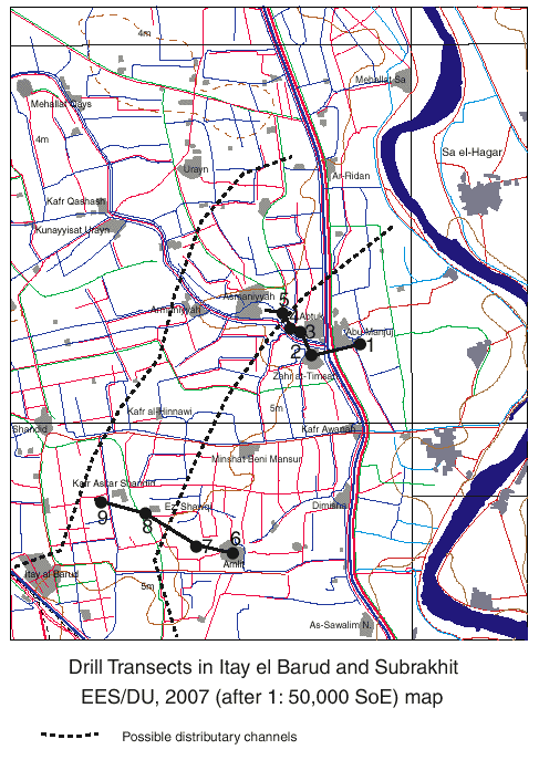
Abtuk transect.
In order to test this information two transects were drilled across the line of the proposed distributary channels. The first was between Zahr el Timseh, Abtuk and Asmanniyah and the second was between Amlit, Ezbet el Kahk and Kafr el Shandid. The first transect identified coarse gravel sediments to the west of Abtuk and one drill auger hole showed the silting up of what is most likely to have been a water channel. The second transect, however, suggested that although there may have been a relatively old settlement at Ezbet Kahki, there was no clear evidence for a river channel in any of the drill auger holes. This result suggests that, of the two possible channel locations suggested by Ghazala, the channel flowing to the east of Itay el Barud, where it divided and went west of Amlit and though Abtuk is most likely. Further work is needed in order to determine the exact path but the approach to Sais through Abtuk-Asmanniyah and thence somewhere in the region of Nikla seems to be certain.
The results from the work suggest that the hypothesis about there being a linking river channel or canal between Naukratis and Sais is quite likely, making the transportation of goods and people very straightforward and ensuring that the capital city was kept supplied with Greek imports, as well as providing the necessary tax for the Temple of Neith as mentioned in the Naukratis and Thonis Stelae. It is hoped that this information will provide some background context for the study of the pottery from Sais.
Survey of Sites in Beheira
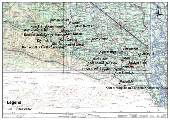
Forty-two places were visited by Joshua Trampier in the Kom Hamada and Itay al Barud areas of Beheira in preparation for a larger topographic, drill auger and ceramic survey in 2008. The work was part of an American Research Center in Egypt fellowship under the umbrella of the Egypt Exploration Society Delta Survey project. The sites visited fall into 3 main categories: those with no remaining archaeological remains at ground level; those with tells, pottery or a few standing remains and major sites already or previously under archaeological investigation. Information was gathered about the places to assess them for the future work planned in 2008 and provide data for the Egyptian Antiquities Information Service.
Site with no visible archaeological remains: Ruzzafa, Kalabt Shafiq, Kom Haeh (SCA 100239), Dilingat, Kom el Hsil, Zawiyet Hamour, Kom el Ahmar II, Kom Zimran, Ezbet el Naggar, Kom Zuweida, Ezbet el Wafaiyya, Sidi Isa, Kom el Zarqa, Damatyuh, Saft el Inab, Sidi Ambar, Biban, Zawiyet Furaj, Kafr Ziyada, Tell Ibqa, Magadieb (SCA 100209).
Sites with archaeological material: Kom Dahab (SCA 100229), Silvagou, Ezbet el Jizawi, Kom Abu el Tubul (SCA 100202), Kom Abu Ali (SCA 100232), Kom Ishrin (SCA 100246), Kom el Gill or Gebel (SCA 100236), Kom el Barud (SCA 100233), Kom Qamha (SCA 100263), Kom Sheikh Said Ahmed (SCA 100244), Kom Hamrit (SCA 100254), Kom el Ghuzz (SCA 100247), Kom Shimuli (SCA 100243), Kom Kortas (SCA 100262), Kom el Ahmar I, Khirbeta, Kom Kharaz, Kom el Maqadis (Kheniza SCA 100208).
Major sites: Kom Firin (SCA 100260, under British Museum concession), Kom el Hisn (SCA 100237).